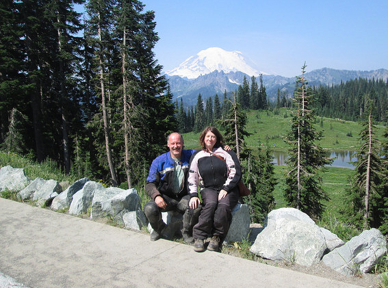
10 days in Washington State:
a Smokey Motorcycle Adventure

August 2017


Every year, my husband and I plan a two-week trip via our motorcycles somewhere. We have been based near Portland, Oregon since 2009, and that has meant we've had some spectacular trips since moving back to the USA - and awesome day rides. On our long trips, we've been to the Yukon and back, to Jasper and Banff, Yellowstone, to national parks in Utah, and, of course, travel all over Europe (before we moved back here).

But one of our very best trips was just last year, when we went to Idaho. Not only was that Idaho trip amazing, but also, we didn't have to travel on the interstate for two days to get there. Because we so enjoyed not having to travel far to begin our adventure last year, we decided to stay close to home again this year and tour Washington state. We've seen only the East, for the most part, mostly on our way back from our second trip in Canada. And, quite frankly, we hadn't liked it. I wanted to like Washington state, and that meant exploring more of it. Also we had only 10 days this year, rather than 14, and didn't want to spend as little time on the Interstate as possible.

2017 Washington Route In case you want the 10-day trip summarized in the briefest of terms:
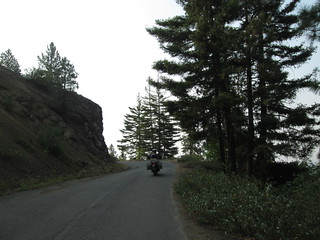
We were in Gifford Pinchot National Forest (our favorite), Mt. Rainier National Park, Wenatchee National Forest, Lake Chelan National Recreation Area, North Cascades National Forest, Mt. Baker-Snoqualmie National Forest, Olympic National Forest, and Olympic National Park, as well as Trout Lake, Packwood, Naches, Ellensburg, Leavenworth, Methow, Chelan, Winthrop, Newhalem, Marblemount, Concrete, Oak Harbor, Amanda Park, Humptulips and Aberdeen.

I've put a map of our route at left.

Here are all our photos, on Stefan's Flickr account.

Before I get to the travelogue in detail, here are some things I wish I had done differently on this trip, that other travelers should keep in mind, about hiking and camping in general in the USA, and about visiting national parks:
And with that, let's get to the Washington state travelogue in detail:

Right off the bat, the trip was off to a difficult start:
But there was no way to delay the trip, and no way to move it, for various reasons I won't go into. So we decided this was what we had, and we would make the most of it.

We got as much as possible ready the night before, and probably did better in getting the bikes packed in advance than ever before. We could have left at 9 a.m. had it not been for that dang test (which I think I did really well on, by the way). I was done before 11, and Lucinda the dog decided she was not going to come back in the house from the back yard. After much begging and attempts at bribes, Stefan opened the back door and walked away - and in she came, to see where we were going. She hates us leaving as much as I hate leaving her...

As we got together the last of our things, a guy came by to pick some plums off our tree and we asked him to take a photo of us just as we were about to get on the bikes and ride off. Then off we went on the very hot, smokey day, by 11:30 a.m. Our route began here in the Portland metro area (as always), from US Highway 26 through Portland and then East on 84. Traffic wasn't bad, thankfully, and the wind wasn't blowing, which was an excellent trade off for it being so hot (I hate hate hate wind when riding my motorcycle). We got off the highway at Cascade Locks, to gas up and hydrate. I saw two or three individual hikers taking a break from the Pacific Crest Trail, as well as an entire family on the trail together. The trail had been on my mind a lot, as I recommended part of it to an Iranian friend visiting from New York City who was looking for a great one-week backpacking trip - I'd done a lot of research, and was kind of ashamed I hadn't known much about it before. Oh, my damn knees... I'd love to backpack again.

Then we went across the Columbia over the beautiful Bridge of the Gods, then East on 14. I was so happy - still no wind! We made a left in tiny Cook, Washington onto Cook-Underwood Road, and through a tiny barely-a-town called Mill A, and left onto Willard Road and, eventually, onto National Forest Road 66. But I had to pull over at some point, because I was getting overheated. I had to stop, take off my helmet and jacket, sit down on the ground and drink as much water as possible. Realizing that I was overheating, Stefan dropped a piece of ice down my back. And I was sooooo grateful. We took our time there in the shade while I cooled down. I ate a banana, and that helped tremendously. It. Was. HOT. We HAD to be careful, not just today, but every day.

Now we were in Gifford Pinchot National Forest, and on a gravel road I've ridden many times, but not for a few years. I felt so much better, and it felt both good and challenging to be on it. It wasn't even 3 hours, and it already felt like we were really, truly on our trip. Other than the horrific heat, it was already a nice ride. This is the time of year when there are lots of people camping on the side of the road picking huckleberries, and local cafes offer huckleberry milkshakes.

We stopped at the Mt. Adams Ranger District, which helps manage the Gifford Pinchot National Forest, to buy a National Parks and Federal Recreational Lands Interagency Annual Pass. Thankfully, they weren't out - but they were out of Senior Passes, which everyone wants because they are about to go up in price (and they should - they've been ridiculously under-priced). For two people, national park passes pay for themselves after visits to just two national parks, plus they give us day use fees at national forests and other public lands managed by federal agencies. We had to stop for photos with Smokey, of course. I realized we'd never stopped there - usually, we were on a day trip or a weekend trip when we go to Trout Lake, so there's never been a need to stop there. I really like stopping at ranger stations on our trips because they often super up-to-date have information on road conditions, fires, special events, camp ground recommendations, etc. It is a shame that Congress, cheered on by the current President, cuts their budget at a time when public lands are so over-used - national forest and national parks are being "loved" to death.

Lunch at Trout Lake was late and, as always, delicious. We sat at our favorite outdoor table by the babbling stream, where I also listened to an old, babbling hippy flirt outrageously with three much younger, foreign backpackers. He was trying hard to wow them with his knowledge of what he claimed was native American philosophy and Japanese wisdom and other New Age crap. I could not stop rolling my eyes. It was cooler out in the shade than in the restaurant, but it was still awful, temperature wise. I felt so sorry for the people inside cooking.   

We had made reservations at the Takhlakh Lake campground, something we had never done before. But, also, for the first time, we were traveling in high season, and we knew it would be full. We arrived with still oh-so-many hours of daylight, so we put up the tent, stripped off our disgusting, sticky, sweaty clothes, put on our bathing suits and jumped in the lake. I am not a big fan of lake swimming, but on this disgustingly hot, smokey day, there was no where else I wanted to be, even at my weight. Takhlakh Lake is not deep - I could swim quite far out into it and still be able to stand. The water wasn't as cold as either of us wanted, but still felt great. The lake is very nice because only human powered and electric powered craft are allowed on it, which keeps things much safer and quiet.

After cooling off, we went back to our site and put our clothesline between one of our bikes and a tree, and hung our bathing suits and sweat-soaked clothes to dry. Stefan had to don mosquito netting around his hat, because the bugs would NOT leave him alone. We decided not to have supper, because lunch had been so huge and so late. It was a relaxing night drinking beer. I couldn't believe how well I'd done in the triple degree heat, nor how absolutely quiet the campground became. Once the ass in the RV stopped running his freakin' generator, I slept unbelievably well. After the lack of sleep from the night before, and the tremendous heat, I really, really needed it. It cooled off a bit, but not enough to zip up my sleeping bag. I slept 10 hours total, but was still up by 6 a.m.

The next morning, we had a lovely breakfast of scrambled eggs and coffee. But Stefan again had to don his mosquito netting on his hat. The bugs were horrendous.

Some people in a site across from us offered us coffee, and we took it - we love free coffee. We talked a bit about our travels, and somehow I got on the subject of chateaus in France, and how many allow camping on the grounds, and one of the guys said, "What's a chateau?" And he was serious. Sigh...  they also started kvetching about how much services had been cut at various campgrounds in national forests, how there used to be a water pump at Takhlakh Lake but now there wasn't - and how they couldn't understand why budgets had been cut because, "Hey, I paid $18 to camp here!" And he wasn't kidding; he thought that was enough for everyone to pay and be able to cover all the costs of having this camp site - and the entire national forest. These people make me want to SCREAM.

Stefan had a dirt road picked out for us to take from the Takhlakh Lake to Packwood, that he had taken on a day trip a few weeks before and that he felt I could do. But mister why-isn't-$18-enough-to-pay-for-everything guy at our campground claimed there was another road that was much shorter and in much better shape. Stefan had mentioned at the ranger station we would be taking forest road 2329, and the ranger had gotten a concerned look on her face and said, "Oh, that road. You are in all terrain vehicles, yes?" So now I was scared of the road, so a shorter, easier route sounded great. Road 23, the well-traveled gravel road to Randle, is closed because of a massive road washout, so we needed some way to get North to Mount Rainier, and we wanted to do something new and interesting. So we loaded up and headed out just after 11 a.m., an hour later than I had wanted, to what we thought was the road the guy had recommended.

That man either was pulling our leg, or we didn't follow his directions properly. After less than a mile of grueling riding over deep ruts, various-sized rocks and massive potholes, all on a steep decline, we came to a large ditch in the still-descending road, a ditch that was filled with a log and branches in order to help cars get over. There we stopped to think about what we were doing. Up to that point, the road had been as difficult as anything I have ever done, and my heart was pounding. My back brakes were gone, too hot to work anymore. Remember: we were loaded down with luggage, not on little dirt bikes. I parked on the road and Stefan went on about another two miles, but the road never got better. Stefan came back and we discussed what to do. He thought we were halfway down the road, so we had been very tempted to continue, thinking the road was about to get better. But after his review of the next two miles, I finally knew that wasn't happening. So I voted we return and try our originally-planned route. Stefan turned my bike around - there was no way I could do it on that steep angle, within all those ruts. And we saw a big SUV coming down the treacherous road. I couldn't believe it such a huge vehicle would attempt the road. I was so glad we weren't on our way back up yet - I did not want to meet any traffic on its way down on this crazy road. It was an older couple. They stopped to ask if we were okay, and we asked them if they knew the road. They didn't. They were lost too. The woman obviously did NOT want to continue, but the husband pushed on. We did not - we went right back out, now that my brakes had cooled off and were working again. I got out much easier than I got in: I always do up on gravel and dirt better than down. We think this incredibly difficult road was National Forest Road 5601. It is extremely hard and I do NOT recommend it unless you are on a dirt bike and you are an amazing rider - and you aren't alone. In fact, according to this federal web site, 5601 Road is closed at milepost 1.95 due to a washout - and I think that ditch we came to is the washout.

So it was back to Forest Road 2329, Stefan's road that he had found weeks before. And except for a crazy man speeding wildly down the road in a white Suburu just after we started it, who easily could have hit us, and the oppressive heat, it was a perfect ride. I loved this road! Perhaps riding that horrible road first made this road seem easy. There are some potholes at the start, but at least during our trip, the rest of the road was in great condition. We crossed the Pacific Crest Trail yet again, and met a lovely couple in their SUV with their two adorable dogs, who gave us advice for when we come back some day regarding campgrounds. It was still smokey, it was still stupid hot, but I was doing okay, temperature and breathing wise (I have asthma). I was so happy that we'd gone to this route! We even passed waterfalls

The road eventually hooks up with Forest Road 21, a "major" gravel road that eventually gets to US Highway 12 in Packwood. But before we got there, a family parked on the side of the road in an SUV flagged me down. Their vehicle had stopped, and the father said, "There's a deputy sheriff just three miles down the road, dealing with a guy who flipped his truck. Could you tell him we need help?" No problem, I thought. Well, after three miles, I saw no sign of any deputy or a wreck. Nor after four miles. Nor seven miles. When we got to US Highway 12, we headed to Packwood and I looked for a towing company. I saw a NAPA Auto Parts, with a large garage, that turned out to be Beslows Towing. So I parked and went in. And the guy was absolutely horrible. As I started telling him about the stranded family, giving him precise details on where the SUV was, he looked down at his paperwork and stopped looking at me, and flat refused to go help. "I have to talk to the driver," he said curtly. I explained that the guy had no cell phone service, and we couldn't bring him on our bikes - we didn't have helmets for him. "I'm not going out there," he said. I couldn't believe it. It wasn't 10 miles away, and we had come straight to him. "Could you get me the number to call the local sheriff?" I asked. "Call 911." You do NOT call 911 for a stalled car. I walked out and, in a voice I wanted him to hear, said, "He is refusing to help. We will have to go to the sheriff's department ourselves." We found the sheriff's satellite office in what used to be an elementary school on the main drag not-too-far-away. I walked in and told the receptionist why I was there. She looked to her right, and I realized she was looking at someone. It was a deputy. He had been the deputy the stranded driver had seen earlier. The wreck had been gone by the time I got to the site, and he had just walked in the door before I walked in. I gave the deputy explicit descriptions of the car, the driver, where he was (I had watched my speedometer to mark the spot) and what the driver said. And then I told him what Beslows Towing had said regarding helping, and he looked over at the receptionist with an expression that, to me, said, "Can you freakin' believe what an asshole that guy is?" I was so grateful the deputy took me seriously and was so ready to help. I'm sorry that I can't find the Lewis County Sheriff's Office on Yelp, because I would love to compliment them there. Here's what I said about the Packwood NAPA store on Yelp.

It was Saturday night, our second night out, and stupidly, we had forgotten to reserve a camp site in advance for that night at the same time when we had reserved our Takhlakh Lake campsite. It's high season in the USA, and first come, first serve camp sites in coastal states, even very far from the coast, or near national parks can fill up by noon at such times. Ohanapecosh campground near the entrance to Mt. Rainier National Park was full, and it wasn't even 4 p.m. We had seen on the way in to the national park that La Wis Wis campground was already full. The woman working the entrance at Mt. Rainier NP was clueless. I asked her if there was rough camping nearby. She looked dazed, and said "Oh, I don't know...." in a far off, slow voice. I asked her if the other camp sites were full. Still dazed. "Oh, I don't know...." Was there a camp site back in Packwood? "Oh, I don't know..." I expect better from national park employees, budget cuts or not! I think if I had said, "Is this Mt. Rainier?" She would have said, "Oh, I don't know...."

We had seen Forest Road 44 near the entrance to Mount Rainier National Park, off state road 123 that leads into the park, which itself is off US Highway 12, and therefore, that road is still in Gifford Pinchot National Forest, where camping outside of designated campgrounds is allowed. Stefan found a great rough camping site very near the start of the road, and I set up camp while Stefan went for beer and ice back in Packwood. We used our motorcycle panniers as our seats and table. We also used them during the night to store our food and toiletries (not a good idea in the tent in such a remote location). Before he left, Stefan had found a large bone near where we wanted to set up the tent, and we had a look and didn't think more of it. But while Stefan was gone to get beer and ice, I went down to the little shelf below our tent, where someone had had a campfire at some point, and then had a look over the side, and saw MANY bones, still in the general outline of the animal that once owned them. There were more bones scattered on the hillside next to it. The animal obviously died right in this spot. We suspect poachers - so many, many people in this country shoot illegally, and we find spent shells in every rough camp site, including this one.

And a reminder that the panniers and top box, as well as the fuel containers, on our motorcycles are from Coyotetrips.com, which makes and curates very high-quality parts and accessories for adventure motorcycles. Who makes and curates them? Stefan! 

Here's what our campsite looked like from Forest Road 44. I felt so bad for the people driving by, obviously looking for a place to camp - I would have been HAPPY to share, but there was no where for someone else to park, unless they were also on a motorcycle. We heated up some canned soup, drank beer, talked about what an adventurous day we'd had, and then went to bed. And we weren't eaten by a bear, though I was scared a limb would fall on our tent and kill us. I had to change my shirt before bed and it was only the end of day two. But it was FILTHY. I had brought all white and light gray shirts, so that they wouldn't heat up in the scorching sun when I had my jacket off. And that meant my shirts looked horrible after just a day. And, once again, it never really cooled off in the night.

The next day was Saturday, the busiest day for any national park. But as I say often on our trips: this is the trip we have. We have to make the most of it. We drove into Mt. Rainer National Park and up to Paradise, getting to the entrance well before 9, and the line wasn't bad at all. It was a beautiful but smokey ride up to Paradise. Mt. Rainer in the smokey distance seemed an illusion. There were many more wildflowers than I was expecting for August, but then again, we had had record-breaking rain in the Spring, and until this week, temps had been mild. Traffic wasn't bad during the ride until we got to the top, near the parking lots. Then it was stupid ridiculous. There were cars and people everywhere. It felt like a mall in the 1980s. Yuck. We were directed into the parking lot farthest from the visitor's center, which is stupid - we're on MOTORCYCLES. We're wearing MOTORCYCLE GEAR. They really want us to walk a mile in that gear, on a triple-digit temperature day? Thanks, guys. There were NO parking spots in this remote lot, so I did what any motorcycle rider does: I squeezed into a place that wasn't really a parking spot, and Stefan parked next to me. Then we schleped up to the Paradise Visitor's Center.

I would love to go to the Paradise Visitor's Center at about 8 a.m. on a weekday, and hike up the main train on Mt. Rainer, then hike back and have a lovely lunch at the center. But today was not that day. We went through the display at the center, which is focused on how the mountain was formed, its volcanic activity, the flora and fauna, and the history around the mountain, including the Civilian Conservation Corps (CCC) back in the 1930s. So much of what they built is still in use all over the USA - very sturdy, well-built structures. The center is nice - even the roof is beautiful - even though it wasn't build by the CCC. The air quality measuring tool in the center said that the air quality was just on the cusp of being bad. I say - it was BAD. No way I would have hiked in that smokey air. The gift shop was having a sale - three t-shirts for $25. I didn't feel like I'd brought enough t-shirts, so I bought the special, and gave Stefan two of them.

We road out of the parking lot and I realized where all those people had gone that couldn't find parking spots: they had parked on the side of the road. The line of illegally-parked cars seemed to stretch on forever. They should close the park when it gets that full! We went back down the road, took a slightly different route, and were out of the park by 10:30 a.m. There was a MASSIVE line of cars waiting to get into the park. So as bad as what it was when we were there, it was going to get much worse later that day.

We went through Longmire and then went left onto National Forest Road 52. All maps say this road is "closed in Winter", and that seems to be code for "this road is fabulous in summer." It was a nice road, in and of itself, going along the Nisqually River, but the sides of the road, along the river, were packed with people camping rough. And a lot of the campers did not look like people we wanted to be next to - they looked like party folks, happy to not have to pay a whopping $18 a night to camp, and free to play music and scream and yell late into the night. At one point, a dog wandered out onto the road. I stopped and honked furiously. Stefan joined me in honking. The dog turned back to the camp site, and someone came up to guide the dog away. I'm sure dogs - and small children - regularly wander onto that road. Be really, really careful on this road on the weekend. In fact, skip it unless you need to go on it and it's not a weekend.

The road took us right back to Packwood, and we stopped for gas, then went to a pizza place for a late lunch. The air conditioning was heavenly, and the staff pretended they didn't see the small dog a guy brought into the restaurant. I saw so many people with dogs, and in this triple degree heat, it was just so cruel. I'm glad the restaurant was accommodating - it was the humane thing to do. While in the restaurant, I checked my texts and my emails. Neighbors were taking care of Lucinda and Gray Max through the weekend, until Sunday night, when a dog sitter would be staying at our house for the week. And one of those neighbors sent me a photo of my other neighbor cozying up to Han Solo in the guest room bed. I fell apart with laughter in the middle of the pizza place. And to be cruel, I uploaded the photo to Facebook. I learned later that the mail man saw it and teased her about it. My work is done... no, you cannot see the photo unless you are my Facebook friend.

We met a motorcycle traveler at the gas station when we stopped at for gas, and more dual sport motorcycle travelers at a grocery store nearby, who very generously offered to share their camp site with us, but they were headed in another direction, and it was early enough on this Saturday night that we thought we could nab a camp site. We headed up to La Wis Wis, which has more than 100 sites. The "camp site full" sign wasn't up, so we had hope. But as we wound our way around all of the various loops, we saw every site full. EVERY SITE. Why the camp host had not put out the "camp site full" sign, we'll never know, but I was pissed. We'd wasted an hour looking for a site there. And I was figuring that our rough camp site from last night, which was oh so nearby, was taken by now. What would we do? There is a private camp site in Packwood, and other than a hotel, we knew it was our only option. We stopped at the message and registration board to discuss our options, and a couple on a small motorcycle stopped. "Are you two looking for a site?" the driver asked. We said yes. "Are you tent camping?" We said yes. And the guy offered to share his tent site with us. He and his wife, on the back of the bike, were camping in a van, and so had plenty of room. They were about to head out for a late afternoon/early evening ride.

We rode to the campsite and unpacked, and I walked back to the message board to pay for our motorcycles - we have to pay an extra vehicle fee, since the site already had a van, but luckily, two motorcycles pay just one fee. After we set up the tent, Stefan used the daylight to service our bikes, oiling the chains and checking to make sure the chains were still tight enough. We also walked around a bit, having a look around the La Wis Wis Guard Station cabin, built in 1937 and currently being restored. The building is listed on the National Register of Historic Places (NRHP), and constructed as a Civilian Conservation Corps (CCC) works project - which means it's incredibly well-built. "The 25 x 32 foot guard station embodies the distinctive characteristics of the Northwest “Rustic” style, typical of Forest Service, Depression-era architecture. This style design incorporates horizontal cedar siding, a tall gable roof with board-and-batten gable ends, exterior stone chimney, and distinctive multi-light windows." The cabin was used as an administrative residence until it went into disuse in the 1990s. The site is being restored by Passport In Time (PIT) volunteers. PIT is a wonderful organization. "Over the years, volunteers have helped us stabilize ancient cliff dwellings in New Mexico, excavate a 10,000-year-old village site in Minnesota, restore a historic lookout tower in Oregon, clean vandalized rock art in Colorado, survey for sites in a rugged Montana wilderness, and excavate a 19th-century Chinese mining site in Hell's Canyon in Idaho." Please follow @PITClearinghaus on Twitter!

The area behind the cabin would be a perfect campsite, and a pox on the camp host for not allowing that. There were so many, many desperate campers driving through the camp ground, looking for a site, and the host never put that sign out. I was worried because the camp site was super loud before night fell, and kids were running around on skateboards, shining lights into everyone's camp site. We didn't cook for supper, because we'd had such a huge, late lunch. We went to bed after nightfall, again lathering ourselves in various pesticides to keep the bugs away. This was proving to be, by far, the biggest bug problem trip ever. I was pleased that the noise almost immediately died down. In our walk around just a bit, I saw that every camp site was already booked the following weekend. EVERY SITE. And most were reserved for the weekend after that as well.

The next day, we had a very quick breakfast and packed up. It was time to head East instead of North. We went back into Mt. Rainier National Park via state road 123, then turned East on 410. We passed more walls that I'm convinced were built by the CCC. The ride was incredibly lovely, and we stopped at Tipsoo Lake, still in Mt. Rainier, for some hydration and photos. We stopped at the Mather Memorial East Portal Information Site and rest area, and were now in Okanogan-Wenatchee National Forest. There are several camp sites along this road, and the day before, we had thought about pushing on for them for Saturday night. However, we asked someone we met who said he camped there if they were full last night (Saturday) - he said his was. The reality is that you cannot go to this area at all without a reservation on the weekends, including Sunday. It was just our third day out, but knew I never wanted to do our motorcycle trip in high season ever again, unless we can do our camping reservations weeks in advance - which will take a lot of spontaneity out of our trips. While we do usually have a route in mind before our trips, we don't know exactly when we will reach various points. With reservations, we will have to have, and keep to, a schedule. Ugh. But the stress of not knowing if we could find a place to stay is just to much.

Okanogan-Wenatchee National Forest is beautiful, and I would love to return and see more of it, but some idiot picked blue as the background for all of the national forest signs, with white lettering. The blue is so faded that most of the signs are now impossible to read, especially the small ones.

A highlight of the drive was seeing a vintage Elks Club sign, out in front of what either used to be an Elks Club or still is one, that isn't listed on the Elks web site (I checked later). I KNOW that was the same sign outside of the Elks Club in Henderson, Kentucky when I was a child - that gorgeous club burned down before I was a teen. I wish I could tell you where that sign was...

We stopped for lunch in Naches off of US Highway 12. I saw a sign for downtown and decided we'd get completely off the highway and see if it was worth it. It was. The downtown is tiny, but not dead. There's a small and very decent looking motel there as well. The Sticky Fingers Bakery and Cafe was VERY good. They were (barely) recovering from a lunch rush when we got there. We had their lunch special: prime rib dip. It was HEAVENLY. And too much food - I took half mine with us and we split it for supper later that day. We ask a waitress for advice on getting out of town and going through Selah, to avoid Yakima. She gave us advice, but warned us of a very sharp, uphill right turn to Old Naches Highway, and of course it threw me into a minor panic: uphill turns are my least favorite things in the world. But it was oh-so-mangeable. We got to state road 821, also known as Canyon Road, and were ready to take it as far North as we dared that day.

It was stupid hot - well into triple digits (well over 40 Celsius). It was a lovely, twisty ride, along the Yakima River, but it was just too hot. It was the hottest I'd felt on this trip. It had to be near 110. And while the canyon is lovely, there is NO SHADE. I kept looking for a place to pull over that had shade, and there was none: every pull off was an unshaded gravel or dirt parking lot full of vehicles for people that were out on the Yakima River. And the river was filled with what looked like drunk idiots baking in the sun as they floated on tubes and rubber boats down the river. When we finally saw a place with shade, it was downhill to get to, and so packed with vehicles that I didn't drive into it. We got to the outskirts of Ellensburg and pulled into a Subway. I was done. I went in and, of course, there were seven chippies from nearby Central Washington University, all unsure about which sandwich was most gluten free. When I finally got to the counter, I took a bottle of Coke out of the fridge and said, "I'll pay for this when these ladies are done ordering." The Subway employee said, "Oh, uh, I don't think I can allow that, uh, I'll have to ask my manager..." and I just said, "Good luck with that," and walked over to the table, took off my jacket and kidney belt and collapsed into a chair to drink my Coke. Stefan was still outside smoking - I couldn't imagine how he was standing the heat. Finally, he came in. I told him I was done. I could not go any further. It was only 3 p.m. He suggested we get a hotel room. With a pool. Thank you, Trivago and Booking.com - we booked a room at Motel 6 from right there in the Subway lobby. I had wanted to make it to Leavenworth that day, and stay in a hotel there that night, but there was just no way. And, yes, I paid for the Coke.

Ellensburg isn't very nice on its outskirts, near the intersection with US 90, but once we got closer to downtown, it was quite charming. There were lots of historic houses and buildings, and the streets were wide and welcoming. It felt like a cute little college town. It felt like Forest Grove, but much more lively. According to Wikipedia, Downtown Ellensburg hosts an event called Buskers in the Burg the last Saturday in September that featuring street performers and a giant puppet art parade.

Motel 6 wasn't so scenic, but WHO CARES THERE IS A POOL. Confession: Motel 6 is my favorite hotel or motel chain. MY FAVORITE. Because it's clean, it's reasonably priced, you can almost always get a pizza or Chinese food delivered to your room, for FAR less than room service, it usually has a fridge, and most people are there just to sleep, so it's quiet at night. And now, most Motel 6s have Wi-Fi. Give me a Motel 6 over any luxury hotel that charges for every little damn thing. We checked into our ground floor room (always preferred when we're on the bikes), took our stuff off the bikes and put it into the room, stripped off our sweaty, sticky clothes and put on our bathing suits for the second time on this trip, and all but ran to the pool. OMG, a pool has never, ever felt that fantastic, not even in Transylvania in Romania. Enjoy the video. After that wonderful dip in the pool, we showered and did some underwear and sock laundry in the sink, then put things out to dry. Then we walked down to Happy's Market, which is one of the best beer and wine shops I have ever been in in my LIFE. They had an incredible selection of beer that impressed even Stefan, including Shiner Bock! We went back to the room, ate our delicious leftovers from lunch and enjoyed our beer - and Stefan attempted to take photos of the incredible smokey moon.

I hadn't slept well the night before - I had woken up several times - so I was hoping I would in a real bed and in air conditioning. Before bed, I indulged myself watching TV - that always feels like an indulgence on vacation. First up, I watched half of Brave. I love that movie! Even if I cry every time she turns her mother into a bear and at the ending. And I was stunned to see an episode of Kolchak: The Night Stalker. IT WAS AWESOME! I couldn't believe it was as good as I remembered when I watched it at 10 years old.  I don't think I have seen it since it first aired back in the 1970s.

And then I slept. Oh, how I slept... I really hated that we weren't camping, on the one hand, but on the other hand, it felt sooo gooood. Some day, this is probably how we will travel all the time by motorcycle, when I decide I can't get up and down off the ground anymore.

After a gorgeous night of sleep in an air conditioned motel room, we awoke at 6 - we'd set our alarms so we would get up and out quickly. We ate the muffins we had bought the night before for breakfast and drank what milk we could get melted - the fridge froze it in the night. We were ready to hit the road by 8 a.m. And it was a shock: it was cool! It was the first cool moment of the trip - other than the motel room. I even got a chill at one point! Brrrrr! I so love my mesh jacket... except the color. We had to be on US Interstate 90 oh-so-briefly (yuck), then we got on US 97 Highway, which was much nice. 

We passed a brown sign that pointed to a place called Liberty, and I didn't see it in time to turn right and head there. A brown sign in the US or in Europe means something historic or public lands. Later, I found out it would have been a great stop, just the kind of thing we love. It was called Meaghersville until around 1912, and was a mining town making its living off the gold in Swauk Creek and the nearby hillsides. Liberty was known for its large gold nuggets, and supposedly a few dedicated miners remain there, hoping to find a mother lode any day now. There are also a fair number of historic buildings around that would have been interesting to look at for at least a few minutes. But... we missed it.

Road to Old Blewett Summit North of Ellensburg We had taken a Washington state road map with us - paper - and Stefan had seen a twisty, paved road leading from 97 that said "closed in Winter" on the map, and eventually lead back to 97. It starts as National Forest Road 9715 and becomes National Forest Road 7320. It's just 11 miles long, but it's quite worth it: paved the entire way, very few pot holes, but a very narrow road. I was really, really glad not to meet any traffic on our way up to or down from the summit, which is called Old Blewett Summit. This is all in Wenatchee National Forest. I loved the ride. I felt like I was doing really well on this ride, almost as well as I rode before my wrech in Utah, when I lost so much of my nerve. I've worked so hard to get it back, and on this trip, I really felt all my hard work pay off.

It was still oh-so-hot and smokey but we were trying hard to stay hydrated. Back on US Highway 97, we turned left eventually to head into Leavenworth. We have heard about Leavenworth since we first moved to Oregon. It was a dying lumber town that remade itself with a Bavarian town. How so many restaurants, hotels and businesses were convinced to make themselves look Bavarian I'll never know. Apparently, Leavenworth's transformation into a theme town was inspired and assisted by Solvang, California, which has a Danish theme. Our first stop was the ranger station there, because I always want to stop at the ranger station, just in case there is something we should know. I loaded up on fantastic little National Forest stickers, with different colors and different themes: hiking, forest fire, tent camping, skiing, compass, etc. I put three on my panniers and Stefan put one on one of his panniers as well - the rest I packed up to bring home and give to friends.

We headed down the street to the visitor's office, and the unsmiling, straightforward person staffing the desk - and, yes, that's very German - suggested a restaurant in answer to my question, "Where can my German husband get a good schnitzel?" We left our motorcycles outside the visitor's office and walked over to the town center. I admit it: the Bavarian look is quite well done. Kitschy, but not painfully so. Except for the fake leaderhosen suspenders for sale ("Instant German!"). Interesting that we never saw any real lederhosen for sale in the town. We enjoyed our walk around, but were sad we couldn't buy any cheese at the specialty cheese shop - it would spoil on the bikes in about 10 seconds in all this heat, as it would be impossible to keep cold in our cooler. We were also surprised that there was no Krampus figures for sale at the Christmas store downtown - Krampus is so vogue! But he was for sale at Krampus Kave, a very nice comic book and sci fi/fantasy fan store in town. I was tempted to buy a few things, but didn't. Oh well, Ganz Klasse! We ate Andreas Keller, per the recommendation of the dour employee at the visitor's office - she said the restaurant had an actual German chef. It was a little hard to find - it's underneath another business. But it was really good. And look at Stefan, look at him with his schnitzel. If he looked at me like that, I'd dance every day! He said it may have been as good as the schnitzel he had in Puebla, Mexico. The staff was super, duper nice and attentive. It was a great lunch.

And then, the rest of the trip...

Here are all our photos, on Stefan's Flickr account.

Return to the Coyotebroad travel home page.

 
Disclaimer
Any activity incurs risk. The author assumes no responsibility for the use of information contained within this document.

_______________________________________________

If you have read anything on coyotebroad.com, PLEASE let me know.
Comments are welcomed, and motivate me to keep writing -- without comments, I start to think I'm talking to cyberair. I would welcome your support for my work as well.


  Quick Links 

Index of resources for women travelers (how to get started, health & safety considerations, packing suggestions, transportation options, etc.
 
Advice for women motorcycle riders and travelers.
 
transire benefaciendo: "to travel along while doing good." advice for those wanting to make their travel more than sight-seeing and shopping.
 
my adventures in Europe, Africa, as well as road trips in the USA.

Advice for camping with your dogs in the USA.
 
Saving Money with Park Passes in the USA.
 
Suggestions for Women Aid Workers in Afghanistan (or anywhere in the world where the culture is more conservative/restrictive regarding women).
 
my adventures in Germany.
 
Advice for Hotels, Hostels & Campgrounds in Transitional & Developing Countries: the Qualities of Great, Cheap Accommodations.

support my work how to support my work.

follow me on TwitterFollow me on Twitter! @coyotebroad.

become Coyote Broad's fan on Facebook.
 

Disclaimer: Any activity incurs risk. The author assumes no responsibility for the use of information contained within this document.

This material is provided as is, with no expressed or implied warranty.

Permission is granted to copy, present and/or distribute a limited amount of material from my web site without charge if the information is kept intact and is credited to Jayne Cravens.

Please contact me for permission to reprint, present or distribute these materials (for instance, in a class or book or online event for which you intend to charge).

The art work and material on this site was created and is copyrighted 1996-2022
by Jayne Cravens, all rights reserved
(unless noted otherwise, or the art comes from a link to another web site).

The personal opinions expressed on this page are solely those of Ms. Cravens, unless otherwise noted.