Part 3: Two Weeks in Idaho
(mostly): a Motorcycle Adventure
September 2016
DRAFT
Introduction and Part 1 (Hell's Canyon
drive from Oxbow Bridge along the Snake River to the Hell's Canyon
dam and then back over Oxbow dam to Cambridge, Idaho, and everything
up to Part 2)
Part 2: Historic Silver City, Idaho
Monday (Day Four)
On our way out of Silver
City, Idaho, I'd formed the plan that we would stop for lunch
in the nearest real city and, while eating, I would call Progressive
Insurance. We pay for roadside assistance! We were now on Idaho
state road 78, headed to Murphy. We immediately realized it was a
tiny town that had no restaurants - but it does have an air strip
right along the road and we
got to see a plane land. Stefan's tire was holding up, so we
headed to Nampa. We stopped for lunch at Idaho Pizza, and while we
ate, I called Progressive Insurance.
I spoke slowly. I thought I made the directions clear: Stefan's
motorcycle had a flat, it was probably the innertube, not the tire,
and we needed to be taken to a place in Nampa that was willing to
change the innertube on a motorcycle. Progressive has all the
information on Stefan's motorcycle, they knew it was a MOTORCYCLE.
The woman I talked to seemed to be understanding what I was saying.
A tow truck driver showed up. He'd been told he would be towing a
small car. He'd been told by Progressive to take the small car to
Discount Tire. Stefan stared at him incredulously. "They don't work
on motorcycles. They don't do anything with motorcycles." The driver
said, "Well, that's where I've been told to take you." I told the
tow truck driver to call the tire place and confirm - he did and, of
course, Stefan was right: they don't work on motorcycles. The driver
said that Canyon Honda, a motorcycle shop, might be able to help us,
and he called them for us - he could have just left us because,
afterall, he'd done what Progressive told him to do. At first, the
dealership told him no - they just didn't have the time to help us
that day. The driver told him we were a couple from Oregon,
traveling through Idaho, that we were stranded unless we got the
tire fixed, and they relented. Part of the reason they relented was
our driver knew at least two of the guys at the shop personally.
Stefan's tire was still looking good, so the tow truck driver
suggested we follow him to the dealership. And we did.
Oh, yes, when I got back, I wrote all this to Progressive. The
response from Progressive:
We apologize for not living up to the high standards we set for
ourselves.
We'll forward your experience to the appropriate department so
that we can prevent this from happening again.
We appreciate your business and the trust you place in us.
That's it! No explanation of why this happened, if this was supposed
to happen or if it was, indeed, supposed to go differently, no
assurance that next time we need roadside assistance, Progressive
will actually give us roadside assistance - just this incredibly
ineffective non-apology apology. So I complained again, and
this time, found out Progressive outsources its roadside assistance
to some company called Agero. A rep from Agero called and read a
prepared statement that is obviously something they recite to every
person who calls to complain. I sat there on the phone, listening to
the recitation, and thought, ARE YOU FREAKIN' KIDDING ME? The rep
never said, "Oh, absolutely, the representative should have known to
call motorcycle dealership and dirt bike shops to find someone to
replace that tire tube." Or, "Hey, that was really awful, I'm
sending you a $50 gas card!" Nope, just a recited apology prepared
by some public relations department somewhere and an assurance that
next time - no, really, NEXT TIME - it will all work out.
Now searching for insurance that actually provides roadside
assistance to motorcyclists, as Progressive / Agero clearly does not
do so.
Canyon
Honda, by the way, was wonderful. I fully expected to
have to wait many hours, and the dealership would have been
justified in making us wait, because they had a lot of customers
ahead of us, but they put
Stefan's bike up on the rack almost immediately. No hole was
ever found in the tire, and the mechanic said the hole in the tube
was quite small. He was really worried that, even with the new tube,
he wasn't really fixing the problem. Spoiler alert: he did fix it.
The fee they charged was quite reasonable, and we had no more tire
problems for the rest of the trip.
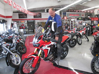 While
waiting for the tire fix, Stefan
got to see a new Honda Africa Twin in person. The original
version of the bike, the one he has, was never sold in the USA, and
it stopped being made altogether in 2003 - or, at least, they ran
out of stock and stopped selling it then. This new version just
started production, and the dual sport world has been all abuzz
about it. He
looked good on it! The Canyon Honda staff were all super nice,
spent a lot of time with us in the showroom that they didn't have
to, and we so appreciated them working us in to fix the bike. Since
Progressive / Agero was no help, we will always be thankful to that
tow truck driver for taking us there and sweet talking them into
fixing the tire for us.
While
waiting for the tire fix, Stefan
got to see a new Honda Africa Twin in person. The original
version of the bike, the one he has, was never sold in the USA, and
it stopped being made altogether in 2003 - or, at least, they ran
out of stock and stopped selling it then. This new version just
started production, and the dual sport world has been all abuzz
about it. He
looked good on it! The Canyon Honda staff were all super nice,
spent a lot of time with us in the showroom that they didn't have
to, and we so appreciated them working us in to fix the bike. Since
Progressive / Agero was no help, we will always be thankful to that
tow truck driver for taking us there and sweet talking them into
fixing the tire for us.
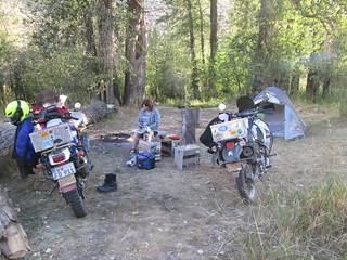
We went back down the road through Murphy, and decided to head to Bruneau
Dunes State Park, about 60 miles away. We got there at 8, it
was still daylight, and were pleased to find we were the only
campers there, and it stayed that way while I took a shower and
washed some things in the bathroom sink. I love this state
park - the bathrooms, the shelters
for picnic tables at tent sites, the incredible views of the
night sky... but I'd really love to go some weekend when we could
visit the site's planetarium. I was also SO tired of these long
days. I like being in a camp site by 6, at the latest. I like time
to read whatever book I've brought - which I hadn't been able to do
even once on this trip. The end of every day saw us absolutely
exhausted. It was hard to get the energy to even write in my travel
journal.
That night, we hung
laundry to dry and cooked supper for the first time - just
some canned soup and bread. We drank beer and star gazed, just like
we had done every night - and it's a wonderful way to end every
evening. This time, I did see a shooting star with a tail, along
with lots of other falling stars. There were lots of fighter planes
going over us as well, and I kept saying, "I hope we haven't gone to
war and we don't know because we haven't seen the news!" It was so
hot, we
didn't use the rain fly on the tent. It was also so quiet, we
had to whisper in order to not disturb the other campers. I know how
voices carry in a campground - I've been kept awake by people having
a conversation in full voice at midnight across a campground. And
with that said, thank you, Bruneau Dunes State Park staff, for all
the signs in the bathroom asking people to PLEASE be quiet; I know
some people see it as nagging, but I really, hugely appreciate the
reminders.
A word about Idaho camp sites. I totally get that non-Idaho
residents have to pay more than Idaho residents. But round off
charges; I don't always have the odd amount of change you ask for at
camp sites, like 14 cents.
And, by the way: I'm
still not a backrest.
Tuesday, Day Five
 It
cooled off in the night. Oh how glorious it felt. But the day was
quickly heating up - another day hot-as-Hades. We walked around the
campground, something I like to always do the night we arrive or in
the morning, to stretch my legs and rest my mind. We found
horseshoes at the other end of the park and tried to play. We're
really, really bad! Even with that walk, we were ready to leave at
10 a.m. Mountain time.
It
cooled off in the night. Oh how glorious it felt. But the day was
quickly heating up - another day hot-as-Hades. We walked around the
campground, something I like to always do the night we arrive or in
the morning, to stretch my legs and rest my mind. We found
horseshoes at the other end of the park and tried to play. We're
really, really bad! Even with that walk, we were ready to leave at
10 a.m. Mountain time.
We debated skipping City of Rocks, which is on the other side of the
state, but decided to go anyway. But that meant taking the
interstate for a bit. It was wretched. Oh how I hate the interstate.
I just really hate going that fast - everyone is going at least 10
miles over the speed limit, and I really don't like going faster
than 65 mph on my bike. We got off at Bliss, and at the service
station, met a big group of very young firefighters based in Merlin,
Oregon, headed to fires in Utah. They just all looked so young to
me... not old enough to fight fires! Any that could grow beards had
beards - a couple of guys, and the young woman with them, didn't
have such.
We passed a sign for Hagerman Fossil Beds
National Monument. We didn't stop, and I wondered if we should
have. That happens a lot on these trips: you pass something you
didn't know was on the way during your trip and think, should we
stop there? And then you do, and it's either awesome or boring, you
just never know. Anyway, reading about it later: In 1929 and
1930, James Gidley of the Smithsonian Institution excavated what is
now known as the Hagerman Horse Quarry. These excavations uncovered
the largest assemblage known of the first single-toed horse, Equus
simplicidens. The Smithsonian excavations resulted in the
collection of more than 20 complete horse skeletons and material
from more than 200 other individuals. Since those original
Smithsonian excavations, tens of thousands of additional fossils
have been found, and new fossils, including those of new species,
continue to be discovered. Today, paleontological specimens from
Hagerman Fossil Beds are housed on-site in the park collections and
at more than 40 academic institutions across the USA. Seldom are
complete skeletons of an animal found; most of the fossils newly
discovered are small, and may be teeth, scales, or parts of jaws or
other bones. There are no open pits to view or field units doing
current collecting of fossils at the monument.
Part of the route we went on was the Thousand Springs Scenic Byway,
probably
the least scenic byway we took on the entire trip, but still
better than the interstate. The byway goes through a few dying small
towns. At one point on the road, there were several springs creating
water falls out of cliffs, but there was no public viewpoint -
just fenced in fee-based cabins, campsites and swimming pools,
meaning you had to pay to see the view. We skipped Shoshone Falls
and the Evel Knievel Snake River jump site as well - I know, how
could I pass up such important USA history? Our impression of Twin
Falls: land of many motels.
We had lunch in the little town of Buhl at a Mexican restaurant in a
former movie theater, and the owner was hilarious. While at
the restaurant, I had Internet access for the first time on the
trip, so I decided to check the news - and I saw that Gene Wilder
had died. And I immediately teared up. I love him so much! Stefan's
favorite movie of his is The Producers, my Mom's favorite
movie of his is Silver Streak, and I know most people love
him most as Willy Wonka. And I adore him in all those roles. But my
favorite of his work is Young Frankenstein. I think he goes
from being fun to being brilliant in that role.
Speaking of movies, nearby was the Parlor
Antiques store, and in the window was a Rex
Harrison-as-Doctor Dolittle doll. But couldn't I buy it and
pretend it's a Henry Higgins doll?
We pushed on, and the heat was exhausting. It was stupid hot. I was
doing my best to drink water whenever we stopped, which meant I had
to pee a lot. I was getting snappy - I don't like riding when I'm so
tired. We stopped at a Dairy Queen for an hour, just to cool off. I
just couldn't go on. And while there, I was reminded of just how
wretched modern country music is. It's CRAP. We had passed through
tiny, all-but-dead towns with no gas, no groceries, and not all that
scenic. It was depressing.
 We
went through Almo, Idaho, which is advertised as historic, but just
seemed like another sad, barely-hanging-on small town. I found out
later that the town long commemorated a massacre
of pioneers by Indians that probably never happened: in 1938,
the Sons and Daughters of Idaho Pioneers erected a marker in
remembrance of the Almo Massacre of 1861, in which, supposedly, a
wagon train of nearly 300 pioneers was surrounded and slaughtered by
Indians. However, the earliest written record of this event is from
1927, and the total absence of information about either the
slaughtered pioneers or the six survivors has led the Idaho State
Historical Society to recommend the removal of the marker. And so:
good for the Idaho
State Historical Society for righting this wrong! Let's face
it: most massacres went the other way, and are rarely commemorated
with a monument.
We
went through Almo, Idaho, which is advertised as historic, but just
seemed like another sad, barely-hanging-on small town. I found out
later that the town long commemorated a massacre
of pioneers by Indians that probably never happened: in 1938,
the Sons and Daughters of Idaho Pioneers erected a marker in
remembrance of the Almo Massacre of 1861, in which, supposedly, a
wagon train of nearly 300 pioneers was surrounded and slaughtered by
Indians. However, the earliest written record of this event is from
1927, and the total absence of information about either the
slaughtered pioneers or the six survivors has led the Idaho State
Historical Society to recommend the removal of the marker. And so:
good for the Idaho
State Historical Society for righting this wrong! Let's face
it: most massacres went the other way, and are rarely commemorated
with a monument.
We passed two dual sport riders posing for photos in front of City
of Rocks signs, and we thought, hurrah, we'll finally get to meet
some other bikers on this trip! Spoiler alert: we never saw them
again.
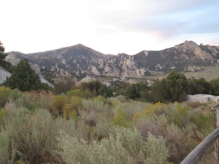
We got to the City
of Rocks National Reserve information center too late - it was
closed. I was so disappointed. Information centers are so helpful -
when they are open. We hadn't been certain we could camp inside the
reserve, and the information brochures were confusing. Finally, we
realized we could, indeed, stay inside the park. We headed onward
and turned
onto the gravel road for the reserve. It was getting dark, but
was still light enough to see
the gorgeous landscape. What an amazing site this turned out
to be! It does very much look like a city of rocks. It's surreal,
like another planet. How has no movie been filmed here?
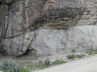
 Pioneers
of the California Trail came through here from the Eastern USA and
sometimes left graffiti using axle-grease from wagons (photo at
left). The California Trail went from western Missouri across the
Great Plains and into the Rocky Mountains in Idaho, and then down
into and across Nevada and into the gold fields of northern
California. It was most heavily used in the 1840s, 1850s, and 1860s.
The wagon trail from the Missouri River to Sacramento, California
was about 1,950 miles (3,138 km). We talked about this a lot that
night, about how long it took emigrants in wagon trains to do
something in three weeks that took us maybe half a day to do.
Pioneers
of the California Trail came through here from the Eastern USA and
sometimes left graffiti using axle-grease from wagons (photo at
left). The California Trail went from western Missouri across the
Great Plains and into the Rocky Mountains in Idaho, and then down
into and across Nevada and into the gold fields of northern
California. It was most heavily used in the 1840s, 1850s, and 1860s.
The wagon trail from the Missouri River to Sacramento, California
was about 1,950 miles (3,138 km). We talked about this a lot that
night, about how long it took emigrants in wagon trains to do
something in three weeks that took us maybe half a day to do.
There are 64 campsites in City of Rocks, many
tucked tightly in among the granite fins and boulders. Some
are at the end of complicated, short curves on the dirt path through
the campground, and some require you to hike a bit from where you
park to where you camp. Some offer shade, via small trees or the
rocks, some don't. Each is quite isolated from others. All are good
for tents, but very few are good for people pulling campers or
driving RVs, especially large ones. It is very hard to get a
campsite in this national reserve on the weekends. We were so lucky
to be there on a Tuesday - all the campsites had reservations for
the following Labor Day weekend. Almost all of the shaded campsites
were taken already, however, and the only open ones, at least that
we saw and other than the one we got, had no boundaries by rocks at
all.
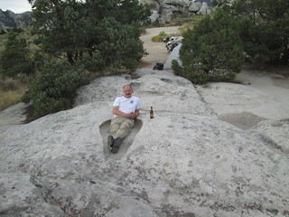 We
camped in a great site, one of the very few with a generous, flat
parking area, and therefore one I could actually drive into, and one
that was also an easy walk to the pit toilet. The views were
stunning. It was like camping in a dream world. We could see Practice
Rock from the site, and we sat and drank beer and watched
people climbing it and repelling down.
Stefan also looked particularly cute in one of the many natural
tubs in the rock. After setting up camp and changing clothes,
we walked around the area, watching two people climb a smaller rock
near our camp. At one point, I looked away for a second, and when I
looked back, I saw something falling off the rock. I gasped, afraid
it was a person. It wasn't - it was one of the bags a climber had
taken up, and was throwing down.
We
camped in a great site, one of the very few with a generous, flat
parking area, and therefore one I could actually drive into, and one
that was also an easy walk to the pit toilet. The views were
stunning. It was like camping in a dream world. We could see Practice
Rock from the site, and we sat and drank beer and watched
people climbing it and repelling down.
Stefan also looked particularly cute in one of the many natural
tubs in the rock. After setting up camp and changing clothes,
we walked around the area, watching two people climb a smaller rock
near our camp. At one point, I looked away for a second, and when I
looked back, I saw something falling off the rock. I gasped, afraid
it was a person. It wasn't - it was one of the bags a climber had
taken up, and was throwing down.
That night, we got yet another stunningly clear night and
outstanding star viewing. Looking at the Milky Way never gets old to
me, and to do it in such a beautiful, exotic place - what an
incredibly lucky girl I am. We so long to be in a place like this
during a meteor shower. We really have to make that happen.
Here's the
official web site for City of Rocks.
And in case you were wondering: I was so missing Lucinda and Gray
Max. I feel a tremendous amount of guilt and worry when I leave
them. I'm still looking for an affordable pet sitter that I really,
really trust. I was always able to find that in Germany, and was
able to find it in Canby, but not in Forest Grove.
Wednesday, Day 6
I got up three times in the night to pee. Yeah, I drank a LOT of
water the day before. It was HOT. I hate getting in and out of the
tent... I love sleeping in the tent, I love my
sleeping bag, but I've had knees at least 20 years older than me
since I was in my 20s. And speaking of old things: my sleeping bag
and my Thermarest mattress are 26 years old. And are better than
anything sold now. My goodness the places they've been...
On this morning, we
cooked on one of the massive rocks instead of the picnic table.
I also saw two deer nearby poking their heads out amid the brush -
wildlife sightings are always fun, and I don't mind seeing deer when
I'm NOT on my motorcycle! We later packed up and before we left, two
very young park employees stopped to chat about our motorcycles. One
was from Wasilla, Alaska, and one was from New Jersey, and leaving
early the next morning for home. They were so nice - I love national
reserve / monument / park employees. The Alaskan told us we
absolutely had to stop
and take the short hike to Window Arch and to stop at a water
pump with the sweetest water we'd ever tasted. He was right on both
counts. At
the water pump, I met the only foreigner we met on the entire trip,
and that's incredibly unusual; on previous trips, we've met foreign
tourists, usually Germans, Swiss, Austrians, Australian or French, a
few times a week. We were realizing just how off-the-beaten-path we
were with this trip - not even the Europeans know about it!
We'd already seen so many amazing things, yet even people in the USA
seemed largely unaware of the awesome sights and sites of Idaho.
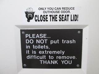 A
word about pit toilet etiquette: The sign in the photo at left, on
the bottom, is found most in pit toilets on BLM land and national
forests campsites. But we also saw this one, with the sticker on the
top with "Stinky" the bear saying "Only you can reduce outhouse
odor." It should be in all pit toilets. Most people don't
know pit toilet etiquette, so let me remind you. You ALWAYS put the
seat lid down when you're done, and you ALWAYS close the door - you
never prop it open. That keeps both the bugs and the stink down. And
you never, ever put food or trash in the pit toilet, because a human
being has to pull that out.
A
word about pit toilet etiquette: The sign in the photo at left, on
the bottom, is found most in pit toilets on BLM land and national
forests campsites. But we also saw this one, with the sticker on the
top with "Stinky" the bear saying "Only you can reduce outhouse
odor." It should be in all pit toilets. Most people don't
know pit toilet etiquette, so let me remind you. You ALWAYS put the
seat lid down when you're done, and you ALWAYS close the door - you
never prop it open. That keeps both the bugs and the stink down. And
you never, ever put food or trash in the pit toilet, because a human
being has to pull that out.
We drove
out of City of Rocks and onto Birch Creek Road - still gravel
- and headed to Oakley.
My materials from the Idaho tourism office said Oakley was historic,
but it seemed quite sad. There are a few historic houses here and
there, but not much in between them, and most of the main street
seemed closed. There's many more historic houses in my home town of
Henderson, Kentucky! Oakley, Idaho really needs an RV park.
I bet a lot of people would love to camp there, and have running
water, and spend the day in City of Rocks nearby. The town really
needs sandwich boards that say "Open" outside of any business that
is open, because we really couldn't tell what was open and what was
closed. I later learned that people descended from the town's Mormon
founders include Jon Huntsman and Mitt Romney. I saw a public park,
and public bathrooms behind it, next to public pool, and hoped they
were open. They were. We had a short break, then
headed North, through the very sad town of Burley, and North
and West on state road 24, through some very boring, mostly flat,
very empty land.
We went through Shoshone, and found it charming. It looked much more
like a historic town worth visiting than Oakley. Had we not already
been to Craters of the Moon, we absolutely would have taken the turn
off and headed there, but we headed North instead. We skipped the
privately-run Shoshone Bird Museum of Natural History - it was
described to us as "unusual", and based on where my imagination took
me - nope. We did stop at the
Shoshone Ice Cave, which at least three people had suggested
we visit. It's surrounded by lava fields, similar to Craters of the
Moon. It's also privately owned and run, and is a classic
American tourist trap, complete with cheesy
dinosaur statue being ridden by an "Indian" in the front and
an amazing amount of kitsch for sale. We arrived just as a cave tour
was starting, and we scrambled to join up, as we would have had to
wait an hour for the next one. The cave really is full of ice all
over the cave floor, and there is a rickety
raised platform that allows you to walk over it. The guide,
who was reciting her speech from memory, said that, indeed, the ice
does sometimes come up to, and a bit over, the rickety platform
sometimes. There is a cinder cone relatively near by - the guide
says it takes a full day to hike there, up it, and back to the ice
cave - and I could clearly see it from the ground, but surprisingly,
couldn't find it on Google Earth. And if you
want to see something really cool, go to Google Earth and look for
Shoshone Indian Ice Caves. You will be able to see the black lava
fields that flowed from this area to Gooding, and be able to see the
nearby, and related, lava flows of Craters of the Moon. It's super
fascinating. Well, it is to me. I'm a science geek.
It was, as usual, stupid, ridiculously, unbearably hot as we left
the site. There was lava
on either side of the road. We headed North, continuing on
state road 75, which becomes the Sawtooth Scenic Byway, Idaho. We
stopped at the Albertson's in Hailey, Idaho. And we were surrounded
by rich people, by Western State Mountain chic. We'd gone from dusty
cowboys in pickups to people wearing the latest fashions and driving
the latest SUVs. We felt so out of place. The aisles in the grocery
were tiny, because most people were pushing the little tiny shopping
carts, not the big ones. We bought beer and some homemade bread.
More about that later. I was really tired and so ready to stop for
the day. We asked the check out guy if there was a place to camp,
and he said "Redfish." Just so you know - that's 70 miles away, and
there's lots of camping much closer to Hailey. It wasn't the first
time we asked for advice on where to camp and gotten bad
advice.
We were in another world, one of incredible amounts of money and
privilege. We drove through the oh-so-chic city of Ketchum and elite
resort city of Sun Valley, and it made me think of Jackson Hole,
Wyoming. And not in a good way. What a life...
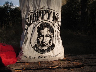 After
we passed the main Sun Valley resort, I saw a sign for "Hemingway
Memorial." Of course! Ketchum, Idaho! Hemingway lived here! In fact,
he died here - it's where he killed himself. Later, I noticed that one
of the plastic bags we were using to keep stuff water proof
was from Key West, Florida and had Hemingway's photo on it. We've
never been to Key West - Stefan thinks it's a bag from his parents.
So, yeah, who knew - this is the year of Hemingway for me! First
Havana, and his house, in February, and now Ketchum!
After
we passed the main Sun Valley resort, I saw a sign for "Hemingway
Memorial." Of course! Ketchum, Idaho! Hemingway lived here! In fact,
he died here - it's where he killed himself. Later, I noticed that one
of the plastic bags we were using to keep stuff water proof
was from Key West, Florida and had Hemingway's photo on it. We've
never been to Key West - Stefan thinks it's a bag from his parents.
So, yeah, who knew - this is the year of Hemingway for me! First
Havana, and his house, in February, and now Ketchum!
Sun Valley is historic luxury resort that's long drawn celebrities
and the oh-so-wealthy. Gary Cooper was a frequent visitor to the
resort, and to Hemingway's house, as were Clark Gable, Errol Flynn,
Lucille Ball, Marilyn Monroe, and several members of the Kennedy
family. Big movie stars still come to Sun Valley. And here we were,
a couple of trashy, stinky bikers driving through, looking over at
the well-heeled skeet shooters at the gun club and thinking, what
are we doing here? I'm surprised no one called the police.
And, then, suddenly, we were in wilderness. No houses, no nuthin'.
We drove to Boundary campground, and before we even turned in, saw
the sign saying the camp site was full. Damn! For an hour, we drove
around looking for a place to camp. We took the turn at Corral
Creek, an easy gravel and dirt road, and saw designated primitive
camping sites on the left hand side of the road - no picnic tables -
a few of them occupied, but no pit toilet anywhere. After passing
camp site 8 or so and feeling like the road was about to end, we
turned around and went back to Trail Creek Road and drove up it,
seeing many more people camping rough off the road. We came to Park
Creek Campground, also full, and continued on, heading to Phi Kappa
Campground. But then the road turned to gravel and went severely
uphill and I stopped and refused to go on. It was getting dark and
starting to drizzle, we'd been riding all day - NO. We both were
really hoping for a camp site with a pit toilet, something we both
really need in the mornings, for reasons I won't go into... But we
realized that we had to go back to Corral Creek, get a primitive
camp site, and just get up early the next morning and head to
Boundary campground for our morning pit toilet needs.
 We
camped in one of the last open sites near Corral Creek, and
felt really isolated, in a great way. No picnic table? No problem -
we used a massive downed log next to our site, as well as our bike
panniers, for tables and chairs (and remember - motorcycle panniers are available
for purchase from Stefan/coyotetrips). We didn't even try to
use the fire pit - things just felt way, way too dry for that.
Stefan used the
charger I got from a nonprofit I vounteer for to charge his cell
phone - I forgot the other charger I have, but was doing well
plugging into bathrooms and RV sites here and there.
We
camped in one of the last open sites near Corral Creek, and
felt really isolated, in a great way. No picnic table? No problem -
we used a massive downed log next to our site, as well as our bike
panniers, for tables and chairs (and remember - motorcycle panniers are available
for purchase from Stefan/coyotetrips). We didn't even try to
use the fire pit - things just felt way, way too dry for that.
Stefan used the
charger I got from a nonprofit I vounteer for to charge his cell
phone - I forgot the other charger I have, but was doing well
plugging into bathrooms and RV sites here and there.
It was another super peaceful night of camping with excellent stars,
this time with the gurgle of water nearby. I love that, though I
sometimes think I'm hearing a conversation - it's amazing how
flowing water can sometimes sound like distant voices. The moon was
far from full and not rising for any part of the night we were
awake, the weather was clear, and we were getting so spoiled with
these gorgeous views of clear night skies.
Thursday, Day 6
I slept 11 hours that night. That's the third time I'd done so on
this trip. It felt wonderful. Stefan said we were at 6450 feet in
elevation, higher than Silver
City, Idaho. We sure weren't as cold as Silver City at night.
Probably because this canyon gets much more sun.
 We
got up early the next day to have our simple breakfast - me having
bread and peanut butter, Stefan having bread, cold cuts, and cheese.
And coffee, of course. And as he cut into that high-end bread
prepared for the ultra chic, Stefan said, "Why do rich people get
the good bread?" And I laughed and laughed and laughed. Stefan also
joked that we were camping for free and we could head to Ketchum now
for a $50 breakfast. We did not do that, BTW. But he was on a
roll...
We
got up early the next day to have our simple breakfast - me having
bread and peanut butter, Stefan having bread, cold cuts, and cheese.
And coffee, of course. And as he cut into that high-end bread
prepared for the ultra chic, Stefan said, "Why do rich people get
the good bread?" And I laughed and laughed and laughed. Stefan also
joked that we were camping for free and we could head to Ketchum now
for a $50 breakfast. We did not do that, BTW. But he was on a
roll...
We were almost ready to leave at 10 a.m. on the dot, earlier than
we'd ever made it out before. I don't like to be in a rush in the
mornings, I really do like to savor beautiful mornings, but I also
really love the ride in the morning - it's the best of the day. We
had maybe 10 minutes to go before being all packed up, and then got
a visit from two BLM employees, and learned that driving past those
"no motorized vehicle" signs with, say, motorcycles, so that your
vehicle can be near your tent, can mean a $250 fine per vehicle, and
that fine usually happens when a law enforcement person stops by
rather than a BLM employee. I'm not going to say further how we
learned that. But we're just really glad we didn't end up with the
most expensive night of camping, that the people that stopped were
BLM employees and not law enforcement...
We stopped at the Boundary campground to use the pit toilets, and on
the way there, saw lots of rich people out walking their dogs - in
fact, every day use site at the campground had a note reminding
people that dogs must be on leashes at all times. The camp host
walked over to talk to us as Stefan smoked - I thought he was going
to hit us up to pay the day use fee because we used the pit toilets,
but he didn't. For a guy wearing "One nation under GOD"
t-shirt, he was really nice. I asked him about the Hemingway
memorial, and he downplayed it - said it was just a plaque. I
looked it up online as I wrote this travelogue, and saw that
it's much more. At first, I was really sad I didn't go. But upon
reflection, what better way to pay tribute to Hemingway than to camp
in the wilderness he loved so much? But I am very sorry that I
didn't know Hemingway is buried in Ketchum. I remember passing the
cemetery - I would have liked to have stopped and paid my respects.
For Whom the Bells Tolls is one of my very favorite books. I
also found out that Hemingway's Ketchum residence is owned by the
Nature Conservancy’s Silver Creek Preserve, but is not open to the
public. The Conservancy took ownership of the house in 1986, but
manuscripts, correspondence and most historical artifacts from the
house were given to the John F. Kennedy Presidential Library.
We headed out on state road 75, the Salmon River Scenic Byway,
Idaho, and saw lots of campgrounds along the road, but I suspect
they were all full the night before, and as it was now almost the
weekend, they would be full tonight as well. We also passed a
National Forest ranger station and information center, and I had
said I wanted to stop at the next one we saw, but it was so early -
we blew right past it.
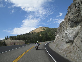 Then
the road got interesting: up and up and, at one point, very curvy.
And I went into my usual anxiety: don't stop, watch the road, look
where you want to go, keep going, don't stop or you will stall and
fall over! Oh how I hate that feeling. I so need to get over it.
After several curves - none of them hairpin - I saw a place off to
the side of the road where I thought I could stop safely, in
front of an Idaho history sign. And
I did. It was still very steep, but at least it was downhill,
which is easier for me to start from than uphill. The views were
stunning. It seemed to me that most traffic was going South, while
we were going North.
Then
the road got interesting: up and up and, at one point, very curvy.
And I went into my usual anxiety: don't stop, watch the road, look
where you want to go, keep going, don't stop or you will stall and
fall over! Oh how I hate that feeling. I so need to get over it.
After several curves - none of them hairpin - I saw a place off to
the side of the road where I thought I could stop safely, in
front of an Idaho history sign. And
I did. It was still very steep, but at least it was downhill,
which is easier for me to start from than uphill. The views were
stunning. It seemed to me that most traffic was going South, while
we were going North.
And I want to take this opportunity now to give another shout out to
the Idaho State
Historical Society for doing such an excellent sign for those
big history signs it has all over the state of Oregon. They not only
provide interesting stories about the area, and are huge and easy to
see, they also almost always provide great place pull over and rest
for a bit. It was interesting to see Lewis and Clark affiliations on
so many of them - the more you travel around Oregon and Idaho, the
more you feel like that traveling party was everywhere.
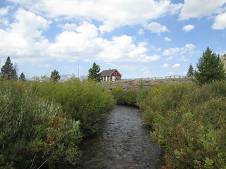 The
landscape was becoming breath-taking. I saw a sign pointing to a
historic ranger station that said it was just three miles away, and
pulled off. I talked to a guy wearing a Google t-shirt and driving
an ATV there at the turnoff, and he said it was interesting enough
to visit, and that the road was easy. He was right - it was a
very easy gravel road, past Dead Cow Ranch, to Pole Creek
Ranger Station. Built in 1909, its primary ranger, Bill Horton, kept
a journal of his life there in that one-room building. He
fenced off a pasture for his horses next to the station, an act that
would provide an important area for the scientific study of native
plant species. The cabin is not much to see, but the view is
incredible, and I liked standing there and thinking about life
there, a life that must have been both busy and lonely, and one
where you had to welcome strangers. Unfortunately, you can't see
inside the cabin. There's a pit toilet in the parking lot, FYI.
There isn't much info online about Bill Horton - that should be
addressed.
The
landscape was becoming breath-taking. I saw a sign pointing to a
historic ranger station that said it was just three miles away, and
pulled off. I talked to a guy wearing a Google t-shirt and driving
an ATV there at the turnoff, and he said it was interesting enough
to visit, and that the road was easy. He was right - it was a
very easy gravel road, past Dead Cow Ranch, to Pole Creek
Ranger Station. Built in 1909, its primary ranger, Bill Horton, kept
a journal of his life there in that one-room building. He
fenced off a pasture for his horses next to the station, an act that
would provide an important area for the scientific study of native
plant species. The cabin is not much to see, but the view is
incredible, and I liked standing there and thinking about life
there, a life that must have been both busy and lonely, and one
where you had to welcome strangers. Unfortunately, you can't see
inside the cabin. There's a pit toilet in the parking lot, FYI.
There isn't much info online about Bill Horton - that should be
addressed.
We continued on in Sawtooth National Forest, nearing the border with
the Salmon-Challis National Forest. I turned off the for ranger
station in Stanley. We went in and asked questions about any nearby
fires. The young ranger was a little smug as she emphasized the
importance of "planning ahead for camping" - which is great if you
are in a car and can carry lots of guides and plan your trip down to
the hour and always have cell phone access so you can call the day
before to reserve a camp site. I picked up a guide to the
Salmon-Challis National Forest and it turned out to be ESSENTIAL for
our journey. We went back to our bikes and up drove a
guy on an older KLR than mine. His name is Brian and he's from
California. He has friends doing the Idaho
Backcountry Discovery Route (IDBDR), which he had been trying
to do as well, but found too difficult, so he was doing his own
alternative route. Brian seemed like quite an experienced rider, and
is very tall, so if he is having difficultly with the IDBDR, then I
would never be able to do it - I was really glad I'd avoided the
route in planning our trip.
Brian told us about where he'd camped the night before: a small,
primitive campground with a pit toilet, about a mile past the
historic ghost town of Custer. Our ears immediately perked up.
HISTORIC GHOST TOWN?!? We are all about historic ghost towns!
Everything he said about the campground and Custer said, "Jayne and
Stefan need to be here!" He gave us info on how to find the town:
the turnoff was at Sunbeam, onto Yankee Fork Road, and there were a
few campgrounds on the way there after the turnoff. There's no sign
for the ghost town on the highway, and that is SUCH a huge mistake!
We thanked Brian profusely for the info and pushed on to Stanley for
lunch. Stanley is mainly off the highway, not along the highway, and
has a terrific restaurant and bar across from the town's gas
station. The bar hosts bands in the summer, I was thrilled to see
that Dale Watson had been there the year before. Stanley would be a
really great place to base yourself for spending a couple of days to
explore the area, enjoy rafting... some day...
And then it was time to go find Custer!
Part 4: Historic Custer, Idaho
Part 5
- Ft. Missoula, Montana
- Wallace, Idaho
- Lake Coeur d'Alene, Idaho
- White Pine Scenic Byway, Idaho
- Hell's Canyon Overlook, Oregon
- Joseph, Oregon
- Painted Hills, Oregon
- Little Crater Lake, Oregon
Know when I travel by:
Following me me at My
@jayne_a_broad Twitter
feed 
This Twitter feed is focused on my experiences traveling, camping,
riding my motorcycle or my bicycle, taking mass transit (buses and
trains), commuting by walking or bicycling, and various other
mostly-personal interests.
Liking my Jayne A
Broad Facebook page 
This Facebook fan page is where I follow USA state parks, national
parks, national forests, and organizations focused on sustainable
tourism, getting children, women and under-represented groups
outdoors, and related international organizations and sites. My
travel-related tweets from the my jayne_a_broad twitter feed
(see below) get posted here automatically.
Return to the broads abroad home
page
Disclaimer
Any activity incurs risk. The author assumes no responsibility for
the use of information contained within this document.
A Broad Abroad | contact me
The content of this page
is by by Jayne Cravens, 2006-2016, all rights reserved