We don't know if we will get to take a two-week motorcycle trip this year, because of Stefan's job. Also, he is taking three weeks of his all-too-little vacation days next year for our motorcycle trip through Baja, California, Mexico and back, and we have been very focused on preparing for that.
But we at least want a short trip or two. I often pick out the places to go on a motorcycle trip, but this time around, Stefan planned everything - the only thing I had to do was book the camp sites in advance (it's high season, so it can be hard to find a place on the fly) and book our dog sitter.
We spent most of our time this trip in Deschutes National Forest. You can jump straight to the photos if you want to skip the travelogue below.
Highlights of our trip:
A reminder: Welcome to Stravaig. It's pronounced straw vague, is an Irish and Scottish word meaning to wander about aimlessly. One goes stravaiging about the roads. Stravaig is probably from an even older and obsolete word extravage, meaning to digress or ramble. I am all about stravaig, both on my motorcycle and in conversations and in writing travelogues.
We packed up the bikes the day before and we hit the road Saturday at 10:30 a.m. We took Oregon state road 47 to Yamhill, gassed up there, then headed on the very nice state road 240 to Newberg, where some festival was just letting out, causing a severe traffic jam as pedestrians flooded the crosswalks, not allowing any cars through - local police just sat in their cars, not helping direct traffic. We finally got through and headed to the truck stop in Canby right next to I5 for our first stop. Heads up: there is a little food cart pod there across from the gas station, and it includes Indian food! What a shame it wasn't lunch time yet!
We got out onto I5 and when I got up to 60 MPH, I felt a bit of a wobble. I thought I was imagining it - it was really windy, and I hate wind and it makes my bike wobble if it's really strong. But after I passed a truck with Stefan was behind me, he headed over to the far right lane and I realized he wanted to exit the highway: he'd seen the wobble when I was passing the truck. I rode to a parking lot and we emptied the panniers and took them off my bike - very easy to do, because of how Stefan (coyotetrips) designed the panniers (yet another reason they are awesome - and mine are the seven-years-old prototypes!). Then Stefan tightened something on the back wheel, we put everything back on and headed back out - not sure it took even 20 minutes tops. It was very cloudy, which was a blessing - horrible to have to do that stuff under the blazing sun, with no shade. I am so unbelievably lucky to ride with my own motorcycle mechanic. I deeply admire women who ride on solo trips and know how to do all this mechanical stuff. I ask Stefan a million questions and try to watch when he works on something, but it's all Greek to me.
We continued South on I5, exiting at Albany to take US Highway 20 East. The wobble on my motorcycle continued, though it wasn't nearly as bad. It was a brand new tire that Stefan just put on a few days before. He had said the tire was a different brand than had previously been on my bike but didn't make it clear to me that this tire is somewhat different in its design, that it's more knobby, and that design might be causing the issue - he just said the wobble would get less after a while. So I spent most of the rest of the trip scared of that wobble, which happened as soon as I went over 60 MPH.
US Highway 20 is more than 3,000 miles and is the longest road in the USA. It begins in Boston and ends in Newport, Oregon. It originally ended at the eastern entrance of Yellowstone Park. I've taken this highway in Oregon, Idaho, Wyoming and Massachusetts at different times in my life - I think of all this every time I'm on 20.
We stopped at the city park in Lebanon and ate the boiled eggs I'd prepared the night before as our lunch that day, then continued on, passing through downtown, where there is an ongoing Quirky Turkey Pageant - decorated turkey statues throughout downtown, each with a theme. I'm so sorry we didn't have time to walk around and look at them and take photos!
After Sweet Home, US 20 starts a really dramatic incline. I stayed at less than 65, to keep my back wobble under control - uphill, that's far easier. We've taken this road many times, in both directions, and the dramatic pass with its views of Mount Washington and the remnants of the 2003 90,000-acre B&B Fire, the largest fire in the history of the Deschutes National Forest, never gets told. We always stop on the pass at the vista point to talk about where we will stop next. We came into Sisters and I got really disoriented - I don't know what my problem was. I almost pulled out in front of someone at a roundabout. I was feeling a bit light-headed and much more tired than I should have.
We went to the Sisters Ranger Station to get advice about whether we should buy a one-day National Forest pass or a National Park pass for the next 12 months - we buy the latter about every other year, but we aren't sure we need it over the next 12 months. After some discussion, we went with the one-day pass, which we could use on any day of our choosing to park at Lava River Cave in Newberry National Volcanic Monument.
 We
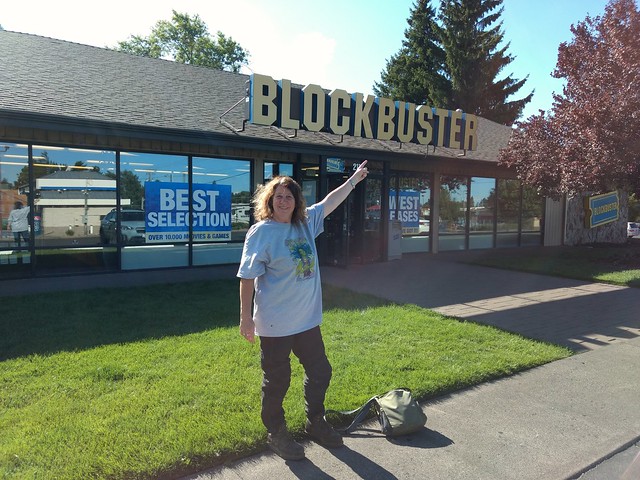
headed on to Bend and switched to US Highway 97. We stopped for gas and
then Stefan went to the nearest grocery store to get ice and beer for the
evening and I stayed behind in the shade next to station. I sat there for
just a few seconds and looked around, and suddenly realized
what I was next to: the last Blockbuster store in the entire country!
We
headed on to Bend and switched to US Highway 97. We stopped for gas and
then Stefan went to the nearest grocery store to get ice and beer for the
evening and I stayed behind in the shade next to station. I sat there for
just a few seconds and looked around, and suddenly realized
what I was next to: the last Blockbuster store in the entire country!
At its peak in 2004, Blockbuster employed more than 80,000 people worldwide, including more than 50,000 in the USA, and had more than 9,000 stores in total, with more than 4,500 of these in the USA. And now, there's just one store. I made a little video of the moment.
Here is the store's Twitter account, @BlockbusterBend. There's also a hilarious parody Twitter account here: @loneblockbuster.
We continued down US Highway 97 and camped rough in Newberry National Volcanic Monument - Deschutes National Forest that first night, because I couldn't find any available campsites online days before, and we knew better to waste any time trying to find something that night - I knew everything was packed. We camped rough off a dirt road off of National Forest Road 9721 (gravel), near the Lava River Cave. The gravel and dirt was well packed, but the ground along the road was thick with dust - about 1/2 a foot/0.15 meter deep, which made it a challenge to find a place to set up the tent and a big challenge to park the motorcycles off the road. It was also really dry - no way we were having a campfire that night. We were in a burn pile clearing and there were cut logs around that were perfect as seats and a table, so we didn't have to take our panniers off the bikes to use for that.
Unfortunately, gun owners had been in the clearing shooting and, as usual, had left enormous amounts of shells everywhere - also known as TRASH. I loathe gun owners - they leave trash, they shoot up signs by the road and they shoot up displays in remote areas. And if "not all gun owners," then I want to see posts by gun owners on social media condemning their fellow shooters from acting this way - but I won't, because all they do is post about how the UN is coming to take their guns away (which isn't happening).
I fixed supper and we ate and drank beer and watched the sun set. Stefan wasn't able to find any Deschutes Brewery beer in Bend that wasn't an IPA - we do NOT like IPAs - so he got Breakside Brewery's True Gold, the one with the moose on the motorcycle. It's one of my favorite beers, actually. And it's what we drank for the rest of the trip, for the most part. Only one vehicle ever came by us: a four wheeler, right at sunset, kicking up a massive amount of dirt that hung in the air in a long, high wall that barely moved for more than an hour. Somehow, we lucked out and the wind held the wall of dust across the road - otherwise, it would have enveloped our camp site and we would have breathed it all in for at least an hour. When it comes right down to it, the wind determined whether or not our trip started off well or horribly.
I didn't drink even an entire beer - Stefan had three - but we were up every two hours to pee for the entire night. After returning from this trip, I found this online:
Increased urine output is a response to hypoxia : increased output of bicarbonate makes it possible to increase breathing. This will make you urinate a lot at altitude. If you aren't urinating much more than you usually would, then you might actually be dehydrated.
And I say all this - about being more tired than I should have, about the dust, about the constant peeing, and on and on - because, as with all my travelogues, I want to emphasize that trips aren't all Instagram moments and just like a brochure implies it will be.
Even with the four wheeler dust, how tired I was, how much I had to pee and how dusty absolutely everything was, I was so glad to be there. I was so glad when I got out of the tent to pee over and over I would look up and see an extraordinary amount of stars, so many that I couldn't even find constellations - just so many, many stars.
After a not great night of sleep - we both were bothered by the nearby traffic on 97 more than we thought we would be, and I don't wear earplugs when we rough camp - we made coffee and ate a simple breakfast: Stefan had meat and bread and I had some peanut butter (those little lunch box tubs are awesome!). I was determined to get to the Lava River Cave by 9 a.m., just as the Sisters Ranger staff suggested. We weren't half a mile from the cave parking lot. We packed up and headed out. We neared the entrance just a few minutes before 9 and there was already a line of cars waiting for it to open. We got our place in line and Stefan got to smoke another cigarette. After just a few minutes, we started to move, and we were directed to park in an area that's clearly marked no parking, but that the staff let motorcycles park in.
Motorcycles can probably always get a parking spot, even on Saturday, without having to show up right at opening, however, motorcycles will still have to wait in line with the cars and wait for every car in front of them to get to park before they get to park, and I'm sure the line on many days is insane. Therefore, even for motorcycles, it's best to get there before 9 so you don't have to wait in line behind cars waiting to park. You can get your day pass for parking at an official visitors center or rangers station before your visit, as we did, or get it at the Lava River Cave site after you park. If you have a National Park pass, it serves as your parking pass.
We got in the first group to get to go into the cave. Before we went in, we got a brief orientation from the ranger that focused on white-nose syndrome (WNS), a fungal disease killing bats in North America. And here is how to decontaminate your gear, especially your shoes, after every cave visit.
The cave isn't like, say, Mammoth Cave, or Carlsbad Caverns, or Lehman Cave, with stalagmites or stalactites. Rather, it's like like walking in a very large stone barrel, or even a European cathedral with a vaulted roof. It's just a mile long. I thought it was a terrific site, even without many features inside. My REI headlamp was woefully inadequate for the cave - I was VERY glad I rented a lantern from the visitor's center. Stefan has a different headlamp than me and it was good enough to get through the cave safely, but my rented light helped illuminate a lot of things, like the high ceilings, which we wouldn't have seen otherwise.
At the end of the cave there is, literally, a stop sign. A group of kids started talking about how it wasn't really the end of the cave and their parents agreed and said it looked like they could keep going and I was pissed. So in my most annoying Aunt Jayne voice, I said, "But no one is going to go past that sign because, as the sign says, they want to let animals and microorganism and features remain completely undisturbed by people, and if you go past that sign, you're going to be disturbing all that. So let's not do that." Everyone got quiet and one of the kids said, "I could still make it" and the Mom reluctantly said no. Dammit parents, quit raising assholes.
We turned around and headed back out, thankful we'd been in the first group and that we'd not been crowded during most of our tour - the entrance was now a crowded mess. We got on the bikes and headed out to nearby Lava Lands Visitors Center, passing a line of cars waiting for parking places at the cave. We toured around inside the center, got more info, got more water, had a look at the view of the lava field, and I suggested we head to Bend, have lunch, and then come back and do the shuttle ride from the center up to Lava Butte, and afterwards head to our reserved campsite for the evening. And that's what we did: after a hearty lunch where I held back and had just ONE enchilada instead of three, we stopped at a grocery for beer and ice just in case there wouldn't be any on the way to the camp site later (turns out there was) and went back to the visitor's center for the shuttle ride to the top of the cone.
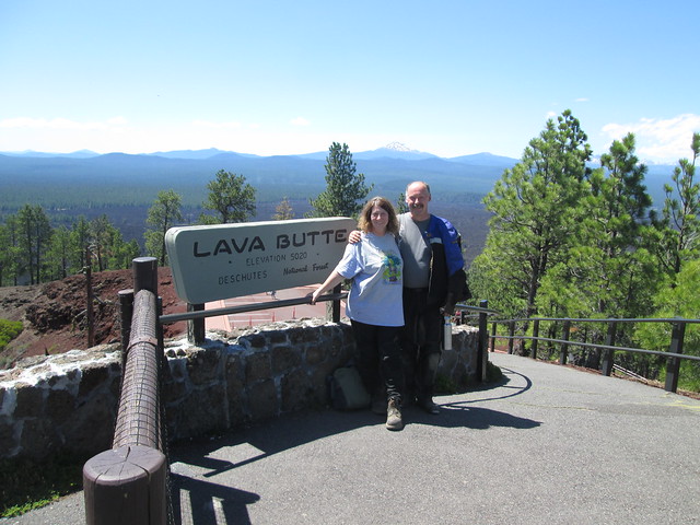 Lava
Butte sits atop a cinder cone and provides sweeping
views of the surrounding ancient lava flows nearby and mountains in
the distance. Lava Butte experienced just a single eruption, about 7,000
years ago. A US Forest Service fire
lookout tower at the top was first built on the summit in 1931 but
what's there now, still staffed by a fire lookout, was built in 1988. The
single lane road loops round and round the cone to the top. After taking
in the beautiful views, we
walked the quarter mile easy hike around the cone, yes, wearing our
motorcycle pants, and still managed to get back in time to take the next
shuttle back down. We also noticed a fire breaking out in the distance.
More on that later...
Lava
Butte sits atop a cinder cone and provides sweeping
views of the surrounding ancient lava flows nearby and mountains in
the distance. Lava Butte experienced just a single eruption, about 7,000
years ago. A US Forest Service fire
lookout tower at the top was first built on the summit in 1931 but
what's there now, still staffed by a fire lookout, was built in 1988. The
single lane road loops round and round the cone to the top. After taking
in the beautiful views, we
walked the quarter mile easy hike around the cone, yes, wearing our
motorcycle pants, and still managed to get back in time to take the next
shuttle back down. We also noticed a fire breaking out in the distance.
More on that later...
Up until that hot hike around the cone, I had continued to be more tired than I should have been: draggy, not real sharp, and like the very back of my throat might be swelling. I was afraid I was getting a cold, and that's why I was so low-energy and having trouble being as focused as I normally am. So I took two aspirin just before that hike. Not sure if it was the aspirin, the hike or what, but once we got back on the shuttle, I actually started to feel a LOT better. Back in the parking lot of the visitor's center, standing next to my bike, a woman complimented me on my pannier stickers. I love my pannier stickers - they are very carefully selected and placed. She asked which was my favorite and I said the one that says "Manufactured by Firefly." She and her two teen age boys immediately began talking about how awesome Firefly was. I hate that it was cancelled after only one season!
Next, we headed just 27 miles to our next destination: south on 97 and then East on Forest Road 21 (paved) to Little Crater Campground next to Paulina Lake. On the way, we passed a plume of thick white smoke just over the ridge on 21 and we think that was part of the fire we had seen in the distance from Lava Butte. A forest service worker was pulling over, coming in the opposite direction - he had also seen the plume. We also passed at least three resorts - this area is big on fishing and "family fun." And I just want to say to every person camping on FEDERAL land and flying a Tea Party flag: fuck off. Go stay at a goddamn KOA, capitalist pig.
We drove into Little Crater Campground and it was awesome to find that I'd reserved the perfect campsite, near the pit toilet and right across from lake access, but without having to go through a campsite to get to the lake. We set up the tent and started unpacking the bike, and saw a motorcycle traveler pass our site, looking for a place to camp. I asked Stefan if it was time to pay it forward and offer to share our site with him. He said sure, and as I walked down to flag the motorcyclist down when he turned around to come come back, I noticed a woman on her own motorcycle, also loaded down, coming up, so I flagged her down and told her we'd be happy to share our site. Our site was HUGE and had PLENTY of room for all four bikes and both tents. While they set up their tent and unloaded their bikes, we changed into swim suits and headed for a swim in the lake. Yes, you get to see me in a bikini. On the opposite side of the lake, we could see thick smoke from the fire we had passed earlier. Later, we learned from Central Oregon Fire Info on Twitter this was the McKay Butte Fire.
 I was
feeling way better. I finally felt at my normal energy level. We changed
into hiking pants and left our fellow campers for a bit while we went to
the Big Obsidian Flow, since our day pass was still good for parking. We
rode two up on Stefan's bike - I love having my own motorcycle, but I do
miss being wrapped around him on the back of his bike. The Big Obsidian
Flow is the youngest lava flow in Oregon. Obsidian is a naturally
occurring volcanic glass. There's a cone of obsidian near Mono Lake in
California and I took Stefan there because I thought it was really amazing
- but, wow, the
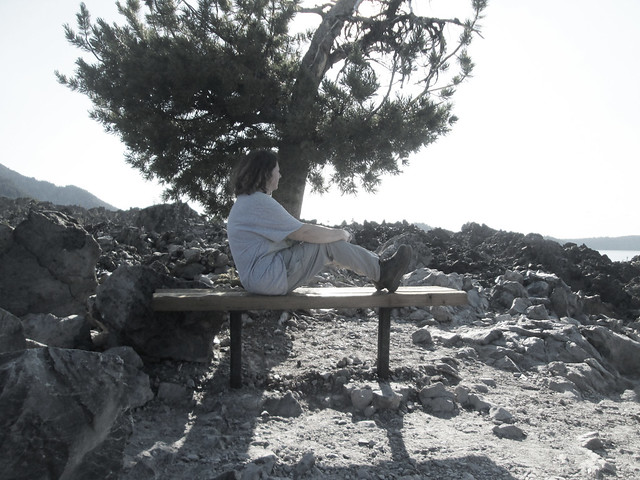
Big Obsidian Flow is MIND BLOWING. And you get to hike through it on
a one-mile trail! The black glass is somewhat transparent (don't take any,
but for sure pick up a piece and hold it up to the sun) and there are MASSIVE
boulders of the stuff! I had to touch
the big pieces. They were so smooth! There's also pumice everywhere.
I was
feeling way better. I finally felt at my normal energy level. We changed
into hiking pants and left our fellow campers for a bit while we went to
the Big Obsidian Flow, since our day pass was still good for parking. We
rode two up on Stefan's bike - I love having my own motorcycle, but I do
miss being wrapped around him on the back of his bike. The Big Obsidian
Flow is the youngest lava flow in Oregon. Obsidian is a naturally
occurring volcanic glass. There's a cone of obsidian near Mono Lake in
California and I took Stefan there because I thought it was really amazing
- but, wow, the
Big Obsidian Flow is MIND BLOWING. And you get to hike through it on
a one-mile trail! The black glass is somewhat transparent (don't take any,
but for sure pick up a piece and hold it up to the sun) and there are MASSIVE
boulders of the stuff! I had to touch
the big pieces. They were so smooth! There's also pumice everywhere.
Please do NOT take your dog on this trail! Their paws will get cut up entirely by the ground. There may not ever be any blood, but you will find out the next day just how much you've hurt your dogs when they can barely walk - this happened with friends' dogs I was hiking with back in the 1990s through a volcanic area.
Stefan wasn't hungry after his huge Mexican lunch, but I was, since I'd shown so much restraint, so I heated up a can of spicy corn chowder and we chatted with our co-campers, Terry and Ellen Hoffman. They had been on the road for a few months, having towed their motorcycles to the state of Georgia from their home in Washington state and then riding back on their motorcycles via the TransAmerica Trail, a highly technical, very difficult route across the USA that is mostly on dirt roads, all of them public but all of them very challenging. The TAT was created by Sam Correro and to get the route and support materials, you buy such from him. I will never being doing this route, BTW - I have a dual sport to ride challenging roads only if they are going to get me somewhere especially scenic or historic. Terry and Ellen are both in their 50s, like me, and I was totally in awe of them riding the TAT. It was fun hearing about their trip and the various challenges. We did what we always do when we meet motorcyclists at a campsite: COMPARE TRAVEL GEAR. Gotta look at each others' stoves and talk about air mattresses and gas containers and how to make coffee on and on. Looking at their small motorcycles, with everything strapped on, in contrast to our larger bikes and panniers, made us feel like we've been glamping.
Stefan and I watched the sunset over Paulina Lake, made even more beautiful by the smoke from the McKay Butte fire. We all went to bed early, before 9:30. The stars were gorgeous once again, not blocked by the smoke, but this time I only got up once in the night to pee - even though I drank almost two entire beers. I felt safe enough to use my earplugs this time - had to, because, of course, other campers decided it was time to fire up their stereos and talk even louder once night fell. And, of course, the camp host, who had chastised us for "coming in a little hot" was no were to be found and did NOTHING about the noise.
Anyway... I got an amazing nights' sleep, the kind of sleep you want on a vacation. In the morning, we all made coffee and I made eggs for breakfast while Terry and Ellen loaded up to get breakfast in La Pine and then get back on the TAT. I sat on Ellen's bike and she sat on mine - now I want a dirt bike too!
We also got to see a helicopter draw water a few times from Paulina Lake to fight the nearby fire.
Stefan said our ride that day would be 50 miles of gravel, and I was nervous. I've done more than 50 miles of gravel: on Steens Mountain, last year. I knew I could do it. But what if it was all uphill? Or all downhill? Or all downhill with curves?
We left Little Crater Campground and headed East on National Forest Road 21, which became gravel and also became Newberry Crater Road. Not that I knew it at the time, but the road went back to being NF Road 21 and then became Pumice Butte Road. Whatever, it was relatively easy, though I did almost go over once when I got into a sunken tire track and had trouble getting out. Eventually we came to an intersection for National Forest Road 18 (China Hat Road) and stopped for a break and where this photo was taken. I was feeling really good! But as soon as we turned right onto NF Road 18, everything changed: the gravel became gray, thick, full of washboards and very hard to ride. My bike constantly felt like it was going to get away from me. We stopped for a break at China Hat Campground, an ultra primitive campground that's a staging area for off road vehicles - it was empty when we were there. I talked about what a hard time I was having, and Stefan gave me a bit of a pep talk. We continued on and, again, I stopped on the road and stayed sitting on my bike, just to take a breather - I was afraid I'd fall over if I tried to dismount. A woman in a pick up truck with a camper on the bed came up - she was afraid she was lost, looking for the South Ice Cave, but Stefan told her she would come to NF 22 soon and that would take her there. She got ahead of us but never very far - she wasn't loving the road either. Other than a truck pulling a very large trailer in the opposite direction, we never saw another vehicle on the road. Indeed, we came to NF 22 and she turned off. We continued on and, at first, the road was so SO much better for, like an entire mile, with hard-packed brown gravel and dirt. I was SO happy. But the gray round thick gravel not only came back, it was worse! I was riding in the center of the road, pounded by endless washboards. I didn't dare try a tire track - the tracks looked like they were coated in deep gravel. But the washboards felt swishy beneath my tires and I felt like my internal organs were shifting from all the shaking. Riding that road was taking every bit of my concentration. I stopped again, just to give my arms a rest, not dismounting because I was afraid of falling, and Stefan told me he'd almost gone over twice. Now, he was just a frustrated with the road as me and he is NEVER frustrated like I am on a road.
Thank goodness I took that off road class in 2018 - I never, ever could have ridden the road otherwise. To say that class changed my life is an understatement. And the KLR is just AMAZING - half my success on a road like this is me, but half is absolutely this bike. I can't believe Kawasaki is discontinuing it! I love my KLR so much!
 Note
that on
Stefan's photo album from our trip that there are no photos of me
riding that gray crap rocks or even photos of us pausing on the
gray crap rocks. One reason is because there was no way Stefan could have
managed to take a photo, even while we were stopped, because the rocks
were slow swishy, we might have fallen over just trying to properly park
the bikes. The second reasons is, to be honest, it wasn't that pretty of a
ride - there really wasn't anything worth taking a photo of. I love the
high desert, I love all the sage brush, but it often doesn't translate
into very good photos.
Note
that on
Stefan's photo album from our trip that there are no photos of me
riding that gray crap rocks or even photos of us pausing on the
gray crap rocks. One reason is because there was no way Stefan could have
managed to take a photo, even while we were stopped, because the rocks
were slow swishy, we might have fallen over just trying to properly park
the bikes. The second reasons is, to be honest, it wasn't that pretty of a
ride - there really wasn't anything worth taking a photo of. I love the
high desert, I love all the sage brush, but it often doesn't translate
into very good photos.
Warning if you go to the area: in addition to the slippery gravel, it's also open range. Only saw on cow, however.
As we passed historic Cabin Lake Guard Station, which is very popular with bird watchers (I found that out later when I was doing research for this travelogue), the road got suddenly and gloriously easy again, with normal brown hard packed dirt and gravel. I was SO happy! It's implied online, on various web sites, that you can camp at Cabin Lake, but we didn't see anyone camping there and, for sure, there's no water access there - there's no lake, no creek, no nothing. I guess the lake refers to what was there a few thousand years ago.
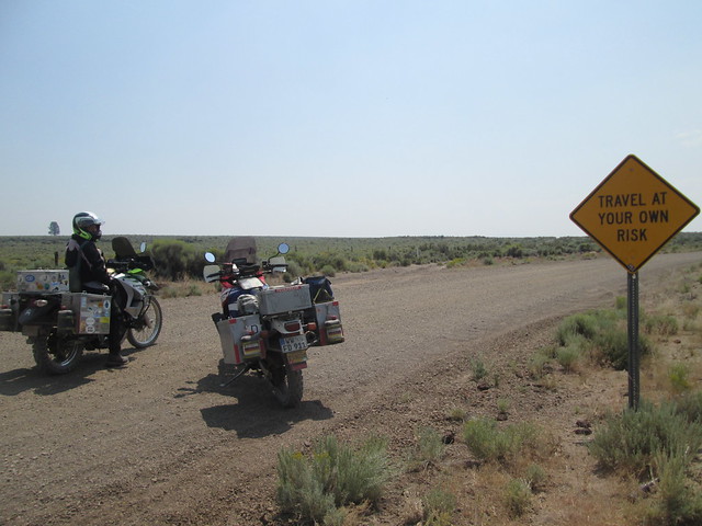
Then we came to a sign that said "Travel
at your own risk" and I was utterly confused. First of all, aren't
we all ALWAYS traveling at our own risk? I mean, isn't that just, you
know, life? Secondly, this sign marked the part of National Forest Road 18
that became quite manageable - therefore, it's turned the wrong way!
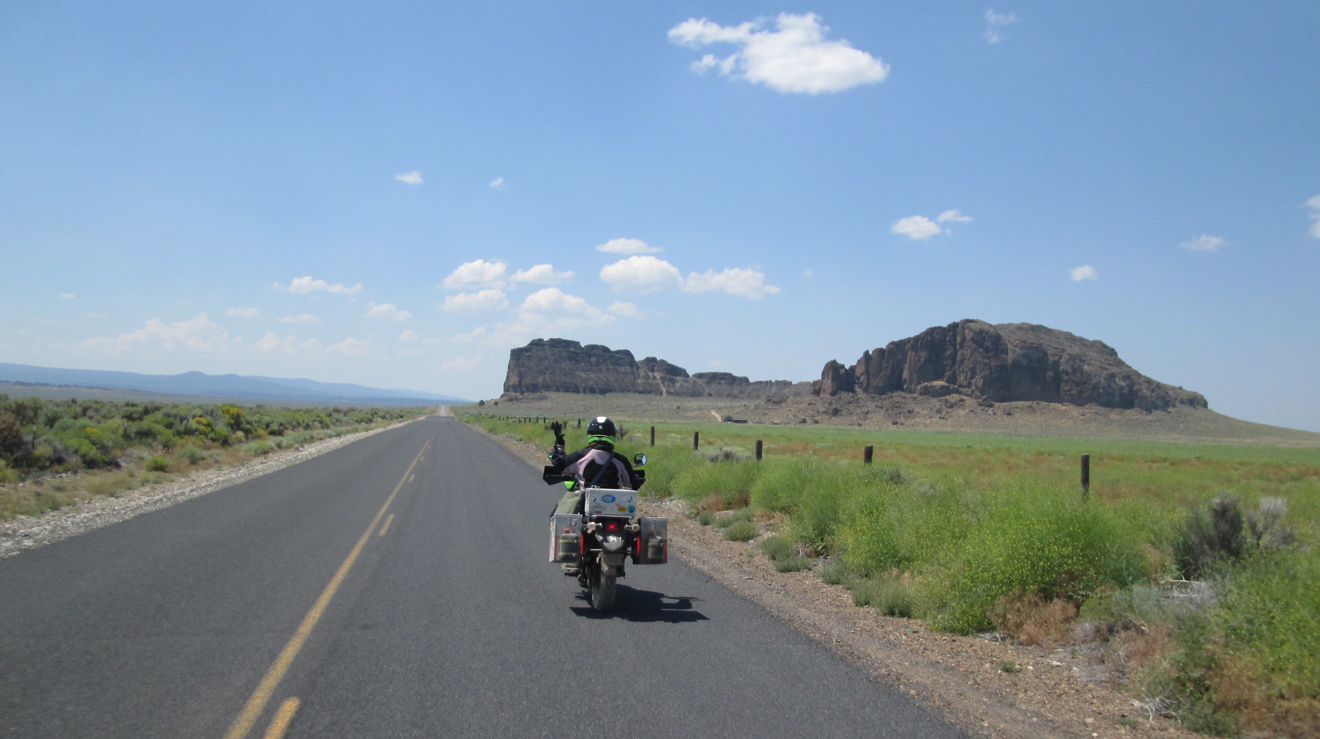
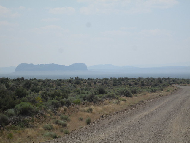 And
we came over a hill and there
was Fort Rock rising up like a desert mirage out of the immense flatness
of Oregon's high desert - it felt like we were in Australia or
Africa. I almost cried. It was so beautiful. I hadn't realized the road
would bring us there directly. I learned later we'd ridden just 35 miles
or so on gravel from Little Crater Campground.
And
we came over a hill and there
was Fort Rock rising up like a desert mirage out of the immense flatness
of Oregon's high desert - it felt like we were in Australia or
Africa. I almost cried. It was so beautiful. I hadn't realized the road
would bring us there directly. I learned later we'd ridden just 35 miles
or so on gravel from Little Crater Campground.
It's a National Natural Landmark and an Oregon State Natural Area, but Fort Rock is not an actual fort; it's an enormous near-circle of towering jagged rock walls, an ancient tuff ring that formed around a volcanic vent in what was a shallow sea in prehistoric times. It's just 50,000 to 100,000 years old. Sandals found in a nearby cave are the oldest ever discovered, dating back around 9,000-13,000 years. Archeological discoveries near Fort Rock and in the surrounding area place a human presence here as far back as 15,000 years.
There's a moderately challenging hike of 2.3 miles around the inside of the circle, but we were there at around 2 and it was way, WAY too hot to hike such while wearing motorcycle pants. So we just hiked a bit up to the rim view that looked down on the parking lot. If you go, have a look at the border fence of the visitor's area - there is a stylistic representation of the constellations, and it's really lovely (forgot to take a photo). The information boards at the parking lot are also excellent. Best times to visit Fort Rock, if you come in summer, are early morning, most definitely. And be prepared for sudden, gusting winds. There's no camping here, which is a shame, but there is a really nice bathroom with flush toilets! What's crazy is that NO ONE I've mentioned this site to has ever heard it - including all the proud native Oregonians I know. But Stefan remembered it from an episode Oregon Field Guide (one of our favorite shows).
Again: what a shame there's no campground there, not even for tent campers - and not one in the tiny town of Fort Rock nearby. We got on the main road and saw the very intriguing Fort Rock Homestead Museum... a kind of ghost town which was closed... and I was disappointed... and then Stefan turned off on what he thought was the road for Hole in the Ground, and he may have been right - but it was white sand and I was just absolutely DONE with this level of difficult riding. DONE. We passed a ranch called Oregon Outback, which looked intriguing, but after just a few yards passed it, I stopped and announced I wasn't going on. I really don't think I could have made the two miles of sand to Hole in the Ground and then back to state road 31, all on sand.
I would like to know if Oregon Outback offers tent camping or horse rentals and outfitting....
We stopped at the junction of state road 31 and Highway 97, South of La Pine. There's a small convenience store there. We got gas, beer, ice and a special bonus item: a can of pineapple. Then we headed South on 97 to Crescent, making a right on state road 61, a new road for us, which took us to state road 58, which we've taken a few times over the years. Headed north a bit for our destination: Princess Creek Campground on Odell Lake, above Oakridge. Last year, on our way back from our Nevada trip, we spent our last night at that site, and it was really special. So before we left on this trip, I made a reservation here, and managed to get a spot again right by the lake. It was great to return there for the last night of this trip, although I kept thinking about my friend Gary Marlin, who passed away a year ago and whose death I found out about in this very campground when I decided to turn on my phone for the first time in days. I miss him so much - he was my political rant buddy on Facebook.
Princess Creek Campground felt like... it felt like home. It's a terrific place to spend an evening, especially if you can get a site right on the water. And while looking out on the water, we got to see a family of otters fishing and swimming by! But while the water is okay for otters, it is NOT okay for dogs or children. Do NOT let your dog or children in Odell Lake until you make sure there are no signs up at the boat ramp about the toxic algae in the lake. We would have never known about it if we hadn't walked down by the boat dock LAST YEAR and seen a warning - which was AFTER we had already been in the water ourselves. Thank goodness Lucy was not with us! This time, as we were contemplating whether or not to get in the water, a camper came into our site and told us DO NOT GET IN THE WATER. She'd learned from a ranger passing through the site that there was very likely toxic algae in the water again, and he had told her two dogs had already died after swimming in Odell Lake. Later, we walked to the boat ramp and saw ONE sign, over on the bulletin board, which no one reads, and which no campers see at all, including all those camped right on the water's edge. I saw a woman arrive with her lab and rushed to warn her - sure enough, she had NO idea. The poster should be on EVERY door of EVERY bathroom! Dogs have become very sick and even died after swimming in and swallowing water affected by toxic algae - and it's not always obvious that the water is affected. The signs of poisoning from this algae take a while to show up, but when they do, they include drooling, weakness, vomiting, staggering and convulsions. If your dog does into water and you have any doubts whatsoever about the safety of the water, do NOT let your pet lick its fur and wash your pet with clean water (drinking water). Oregon Public Health officials also advise that toxins cannot be removed by boiling, filtering or treating the water with camping-style filters.
Three days after we got back, the Oregon Health Authority tweeted a very weekly-worded warning about the toxins in the lake. So, here's my advice: When in doubt, stay out! Unless you have checked water advisories online before going and walked around and looked at every bulletin board and you talk to someone who has let their dog run around in the water for the two days prior and their dog is fine, do NOT let your dog in the water!
Even with the toxic algae, I love the area around Oakridge, Oregon so much, almost enough to want to live there. I love the lush, green environment, the rivers, the mountains, and the beautiful roads. I always think about Eric and Gail Laws when we are there, legendary motorcycle travelers who lived in nearby Westfir. Eric and Gail road two-up on their motorcycles on every continent, including across Russia in 1992, which earned them a place in the Guinness Book of World Records as the first people to cross Russia by motorcycle, a 6,998 mile trip from Magadan to Moscow. Talk to enough motorcycle world travelers and, eventually, you meet people who knew Eric and Gail - including Stefan, who met them in a small town near the Meteora Monasteries in Greece in 2006. Many of those motorcycle travelers eventually found themselves at Eric and Gail's hidden homestead in Oregon to stay a night or two on their way from Canada to Mexico, or midway through a grand tour of the USA. I wrote an article about Eric and Gail for a motorcycle magazine, and got this quote from Eric: "When you travel outside North American, many people end up helping you. How can you repay? You can help other travelers." It became our mantra. Eric and Gail invited motorcycle travelers to their home year round. Even when they weren't there, the year-round caretaker on site knew to welcome any motorcyclist who might show up. In addition, every summer, Eric and Gail opened their river-side estate to international motorcyclists and those interested in such, for a small, low-key gathering, more camping soirée than rally... except for the burning of the motorcyclist effigy. They called it Burning Moto Man, and no other motorcycle event has been as good, IMO - it was warm, friendly and fun, without all the posing and macho crap of other rallies. It was about being helpful and friendly and inspiring, not one-upping each other or disagreeing with someone's travel account. We had to skip the event in 2012 because of Stefan's work, but were so looking forward to 2013. And then the devastating news: Eric had passed away on May 4, 2013 due to cancer. Gail said he fought it hard for 9 months.
Eric and Gail started a web site to help adventure motorcycle travelers, named for their beloved, and now deceased, dog, Tynda. It was a hot mess in terms of design... and it's long gone from the Interwebs. But in writing my article about them, I pulled off this sage advice:
IF YOU THOUGHT RIDING YOUR MOTORCYCLE IN SOME OF THE COUNTRIES MENTIONED HEREIN IS DANGEROUS, WAIT UNTIL YOU GET OFF.
Yeah, that's Eric - loved his sense of humor. Here are Eric's recommendations regarding some items to take on long trips:
#1 Snap lock for keys.
Ever get on your motorcycle and realize that your keys were still in
your pocket. Especially, under the rain gear. How many times does it
take. Use a snap lock and snap them to your jacket zipper. Keeps you
from feeling foolish..
#2 Small knife.
Place it on your key chain and snap lock.
#3 Ear Plugs.
If you don't know why you should use ear plugs, it is too late. But
often in foreign countries they play loud music all night in the
campgrounds or there may be a bar/disco close by.
#4 Small Flashlight
In your pocket or on your key chain for emergency or tent use.
#5 Surgical gloves
Even if the foreign doctor has them, they come in handy for those dirty
jobs you do, such as when sewing up wounds.
#6 Face mask & mud flaps
Some riders have complained to us of the dust in South America, Russia
and other countries. Helpful if dust bothers you while riding alone or
behind others.
#7 Candle
Helpful to take moisture out of tents or for those hotels that have
limited electrical hours. Scented candles help in the unventilated
rooms.
#8 Bungle cords
The very small kind have many uses, especially to strap on items at the
last minute.
#9 needles (syringes)
The doctor may not have fresh ones and may want to reuse old ones.
#10 Business cards
Convey info quickly on that rainy, windy road when you meet a traveller
coming from the other way. Use email and have it on your card. This is
the year 2000, after all.
A little larger items are:
#1 Photo album
Can't speak the language, even so, it shows where you live and your
family, pets, etc.
#2 Motorcycle cover
Hides your motorcycle, and can be used as your ground cover, raincover,
etc.
#3 Small dictionary
After you use it give it away as a gift. English/Spanish or whatever.
#4 Hand soap & handiwipes
You are not as clean as you think and do you think they have soap in
that toilet or kitchen.
#5 Sheep skin
Can be used on your seat for those long journeys and if big enough
underneath your sleeping bag. Remove the sheep before using, unless
going to a cold climate.
#6 Water pump
Water is the liquid of germs. Beer and bottled water are not always
available.
#7 Siphon Hose
Has many uses especially when you run out of gas.
In looking at Google Maps of the area to write the blog you are reading now, I was stunned to see Eric Laws name on the map - he's marked as a business because he was a lawyer who still practiced sometimes from home. It was kind of jarring to see his name there after all these years. I also noticed that very nearby where they used to live is Tired Dog Ranch, which has cabins and a yurt for rent, as well as space for tent campers.
After an evening of nostalgia and beer and watching otters swim by, we popped in our earplugs and went to bed. After a wonderful night's sleep that wasn't anywhere near as cold as I had prepared for, we made some coffee and ate very light - we wanted to save ourselves for a big brunch in Eugene. We headed down through Oakridge - it was awesome because there was no one behind us, meaning no one annoyed that I wasn't going 90 MPH down state road 58. And I hit 70 a few times and... no wobble! I had finally worn my new tired down enough that the wobble was gone.
We stopped at the parking lot next to Lowell Covered Bridge and Dexter Reservoir, which we did last year too, and we had suddenly gone from sun to a cold and cloudy day - just like last year! I've been there probably four times, but I've never gone to see the Dexter Lake Club - not much for Animal House nostalgia, even if I do sometimes quote from the movie.
 Last
year, on our way back from our Nevada trip, on our last day out, we
discovered GJ's
diner in Eugene, and I lost my mind over how freakin' DELICIOUS it
was. Stefan suggested we end this trip there as well, and of course I said
YES! Here's GJ's
Menu - simple, basic, delicious diner food. I got a half order of
biscuits and gravy and two eggs over easy, thoroughly and completely
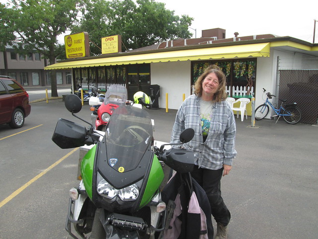
blowing my diet program away and I DON'T CARE IT WAS HEAVENLY. At left is
a photo of me after eating at GJ', which I like to call JJ's, after the
diner in one of my favorite shows, Parks & Recreation. I so
wish we had a diner like this in or near Forest Grove, with great food and
great service (we don't - AT ALL). Didn't get a photo of the couple there,
in bear onesies, leaving after eating with their kid. Oh, Eugene...
Last
year, on our way back from our Nevada trip, on our last day out, we
discovered GJ's
diner in Eugene, and I lost my mind over how freakin' DELICIOUS it
was. Stefan suggested we end this trip there as well, and of course I said
YES! Here's GJ's
Menu - simple, basic, delicious diner food. I got a half order of
biscuits and gravy and two eggs over easy, thoroughly and completely
blowing my diet program away and I DON'T CARE IT WAS HEAVENLY. At left is
a photo of me after eating at GJ', which I like to call JJ's, after the
diner in one of my favorite shows, Parks & Recreation. I so
wish we had a diner like this in or near Forest Grove, with great food and
great service (we don't - AT ALL). Didn't get a photo of the couple there,
in bear onesies, leaving after eating with their kid. Oh, Eugene...
We got back out on the street, following the signs to 99 going North, which is not pretty but still better than I5, then took 99E going North at Junction City - 99W is, IMO, a pretty road, through farmland and trees, with mountains in the distance. It goes through Monroe, a tiny town which looks charming but we've never stopped, and goes by the 5,325 acre William L Finley National Wildlife Refuge, providing wintering habitat for dusky Canada geese, and Peavy Arboretum, another good place to hike and two more places we've never stopped at. And then back through McMinnville, Yamhill, Gaston and to home.
Where a very happy Lucinda the dog greeted us.
One last note: we were stunned at how few motorcyclists we saw on this trip. We saw one big group of Harley riders, some small groups of Harleys, but just one adventure rider. Other than Ellen and Terry, that was it. The weather was perfect. The riding is superb. Where is everybody?
Also in 2019: Motorcycle
Tour of Northern California & Southwestern Oregon: 11
days, 10 nights, 2095 miles, September 2019. Cascade-Siskiyou National
Monument, McArthur Burney Falls State Park, Salmon River Road between
Somes Bar and Cecilville, California, Shasta-Trinity National Forest,
California state road 36, Empire Mine State Historic Park and Grass
Valley, Downieville, Modoc National Forest, Bear Camp Coastal Route in
Josephine County, Oregon & my first water crossing!
Also see:
My favorite North American Ghost towns / historic mining towns / pre-1900s towns
Advice for Traveling Around the USA Camping & Hiking
Women's Safety While Tent Camping
For Women Who Travel By Motorcycle (or want to)
Advice for Women Motorcycle Travelers: Packing
advice for Women Motorcycle Travelers: footwear (shoes & socks).
Advice for Women Motorcycle Travelers: Transportation and Accommodations Choices
Suggested short motorcycle routes in Oregon and Washington state (from an hour to all-day; many can be linked together to create longer trips).
transire benefaciendo: "to travel along while doing good." Advice for those wanting to make their travel more than sight-seeing and shopping, whether in your own country or abroad.
Steens Mountain, Oregon, Great Basin National Park and Rachel, Nevada. We spent 13 days, going over 2657 miles / 4276 kilometers, mostly in Nevada in 2018. It was a terrific, but incredibly hot and smokey, trip. Also see all of our 2018 motorcycle adventures.
Olympic National Park and Forest, the Northern Cascades, Mount Rainer - our epic, smokey Washington state trip. 2382 km / 1489 miles. And all of our 2017 motorcycle travel (lots of local trips around North Western Oregon).
Two weeks in Idaho: Silver City, Hells Canyon, Silver City, Idaho, Bruneau Dunes State Park, City of Rocks National Reserve, Sawtooth Scenic Byway, Salmon River Scenic Byway, Custer, Idaho, Ft. Missoula, Montana, historic Wallace, Idaho, Lake Coeur d'Alene, White Pine Scenic Byway, Hell's Canyon Overlook, Oregon, Joseph, Painted Hills, and Little Crater Lake in Mt. Hood National Forest. 4280 km / 2675 miles. At least 120 miles of gravel. One of our FAVORITE trips. And all of our 2016 motorcycle adventures.
Two trips in Canada, one in 2015 and one 2010. Most recently, in 2015: to Stewart, British Columbia, Hydar, Alaska, the Stewart-Cassiar Highway, the Yukon, the Alaska Highway - a grand tour of British Columbia. 5954 km / 3700 miles. And, earlier, one of my first motorcycle adventures, in southern British Columbia and Alberta, Canada, to tour Jasper, Banff and much more. See all of our 2015 motorcycle adventures and all my 2010 motorcycle adventures.
Grand Utah tour: Moab, Arches National Park, Canyonlands National Park, Capitol Reef National Park, Goblin Valley, Cleveland-Lloyd Dinosaur Quarry, Sheldon National Wildlife Refuge, and camping in a cow pasture in a desert of Nevada and at Farewell Bend Oregon State Park. And my first motorcycle wreck. 2989 miles / 4810.329 kilometres. Also see all of our 2014 Motorcycle Travel.
Eastern Oregon long weekend: Antelope, Oregon amid the ghosts of the Rajneesh colony, seeing the Alvord Desert for the first time. Also: Sweet Home, Sisters, Antelope, Shaniko, Fossil, Condon, Heppner, Ukiah. 2012. 2012 was our busiest motorcycle travel year.
Weekend camping and riding trip in Eastern Oregon, Gifford Pinchot National Forest / Southern Washington State, sites around Mt. Adams and Mt. St. Helens. 2012.
Lava Beds National Monument, Lassen National Monument, Emmets Pass, Devil's Postpile (California), the Alvord Dessert (Oregon), and everything in between. September 2012. 2446 miles / 3914 km miles.
Yellowstone, Western Montana, Wyoming & more. Including US Highway 12 through Lolo Pass, Nevada City (Montana), Craters of the Moon, Bruneau Dunes State Park, and John Day Fossil Beds National Monument. The trip ended at the legendary Burning Moto Man 2011, in Westfir, Oregon. 2680 miles. We also spent one week in Washington state, September 2011 to celebrate my husband's 40th birthday, visiting Mt. Rainier, Mt. St. Helens, Ape Cave, ice cave and lava tubes, Gifford Pinchot National Forest and a bit of Mt. Hood
Oh Canada (and more). It was nothing short of epic: British Columbia and Alberta, Canada, Jasper, Banff and Kootenay National Parks for the first time, Glacier National Park, Swan Lake National Park, Garnet ghost town in Montana, and so much more, all via motorcycle. 2,535 miles / 4,056 km. And it wasn't our only trip in 2010. We went back to Jasper and Banff in 2015.
The Lost Highway motorcycle tour (my first trip on my own motorcycle): Del Norte Coast Redwoods State Park, Ferndale, California, the notorious Mattole Road from there to Petrolia, Humboldt Redwoods State Park, Avenue of the Giants, Bigfoot Scenic Byway and my first (and thus far only) Horizons Unlimited rally. About 1000 miles. 2010.
Eastern Europe three week trip (pillion): Poland, Slovakia, Hungary, Romania, Bulgaria, Macedonia, Albania, Bosnia & Herzegovina, Croatia, Montenegro, Slovenia. Amazing. 2008.
Northern France (pillion): ancient sites, Roman sites, medieval sites, World War I sites, World War II sites... Bayeaux Tapestry. Mont St-Michel, Carnac, and so much more. Amazing food, amazing sites. Good camping. Two weeks. 2007.
Scotland (pillion): Leaving from a port in Belgium, arriving in Hull, England. Highlights: Hadrian's Wall, Braemar, the main Orkney Island, Kilmartin, Ballmoral, Loch Ness, the small stone circle near Tarland... more than I can summarize here. Two weeks. 2006.
Bruges, Belgium (pillion): Long weekend. 2005. This was more of a boring ride on a motorcycle to get some place, followed by an amazing time walking around Bruges (great beer!).
Norway & Sweden (pillion): Kristiansand, fjords, sea life, mountains, glaciers, a rock slide, a crazy ferry ride and primitive rock art. Two weeks. My first motorcycle trip! 2004.
about me | contact me | support this web site